Lama (Korsika)
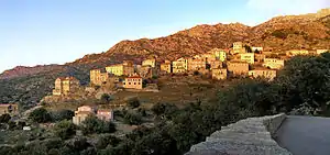
Lama ist eine Gemeinde auf der Mittelmeerinsel Korsika in Frankreich. Sie gehört zum Département Haute-Corse, zum Arrondissement Corte und zum Kanton L’Île-Rousse. Sie grenzt im Norden an Urtaca, im Nordosten an San-Gavino-di-Tenda, im Südosten an Sorio, im Süden an Pietralba und im Westen an Novella. Das Siedlungsgebiet liegt auf ungefähr 480 Metern über dem Meeresspiegel.
| Lama | ||
|---|---|---|
| ||
| Staat | Frankreich | |
| Region | Korsika | |
| Département (Nr.) | Haute-Corse (2B) | |
| Arrondissement | Calvi | |
| Kanton | L’Île-Rousse | |
| Gemeindeverband | L’Île-Rousse Balagne | |
| Koordinaten | 42° 35′ N, 9° 10′ O | |
| Höhe | 120–1535 m | |
| Fläche | 20,01 km² | |
| Einwohner | 146 (1. Januar 2019) | |
| Bevölkerungsdichte | 7 Einw./km² | |
| Postleitzahl | 20218 | |
| INSEE-Code | 2B136 | |
 Lama | ||
Sehenswürdigkeiten
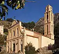
- Kirche Saint-Laurent
- als Monument historique eingestufte Kapelle San Lorenzo
 Kapelle San Lorenzo
 Kirche Saint-Laurent
Bevölkerungsentwicklung
| Jahr | 1962 | 1968 | 1975 | 1982 | 1990 | 1999 | 2008 | 2012 |
|---|---|---|---|---|---|---|---|---|
| Einwohner | 249 | 237 | 174 | 120 | 98 | 130 | 176 | 164 |
This article is issued from Wikipedia. The text is licensed under Creative Commons - Attribution - Sharealike. The authors of the article are listed here. Additional terms may apply for the media files, click on images to show image meta data.
