La Chapelle-Glain
| La Chapelle-Glain | ||
|---|---|---|

|
| |
| Staat | Frankreich | |
| Region | Pays de la Loire | |
| Département (Nr.) | Loire-Atlantique (44) | |
| Arrondissement | Châteaubriant-Ancenis | |
| Kanton | Châteaubriant | |
| Gemeindeverband | Châteaubriant-Derval | |
| Koordinaten | 47° 37′ N, 1° 12′ W | |
| Höhe | 46–99 m | |
| Fläche | 34,77 km² | |
| Einwohner | 798 (1. Januar 2019) | |
| Bevölkerungsdichte | 23 Einw./km² | |
| Postleitzahl | 44670 | |
| INSEE-Code | 44031 | |
 Mairie La Chapelle-Glain | ||

La Chapelle-Glain ist eine französische Gemeinde mit 798 Einwohnern (Stand: 1. Januar 2019) im Département Loire-Atlantique in der Region Pays de la Loire; sie gehört zum Arrondissement Châteaubriant-Ancenis und zum Kanton Châteaubriant.
Geografie
La Chapelle-Glain liegt 31 Kilometer nördlich von Ancenis, 55 Kilometer westlich von Angers, 66 Kilometer nordöstlich von Nantes und 85 Kilometer südlich von Rennes am Fluss Petit Don. Nachbargemeinden sind: Juigné-des-Moutiers, Saint-Julien-de-Vouvantes, Petit-Auverné, Vallons-de-l’Erdre und Le Pin im Département Loire-Atlantique sowie Challain-la-Potherie und Ombrée d’Anjou im Département Maine-et-Loire.
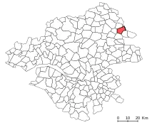
Lage der Gemeinde La Chapelle-Glain im Département Loire-Atlantique
Bevölkerungsentwicklung
- 1962: 1211
- 1968: 1097
- 1975: 898
- 1982: 838
- 1990: 808
- 1999: 761
- 2017: 812
Sehenswürdigkeiten
- Château de la Motte-Glain
- Kirche St. Peter und Paul
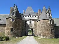 Château de la Motte-Glain
 Kirche St. Peter und Paul
Persönlichkeiten
- Didier Barbelivien, französischer Komponist, Liedtexter und Sänger
Literatur
- Le Patrimoine des Communes de la Loire-Atlantique. Flohic Editions, Band 2, Charenton-le-Pont 1999, ISBN 2-84234-040-X, S. 1101–1104.
This article is issued from Wikipedia. The text is licensed under Creative Commons - Attribution - Sharealike. The authors of the article are listed here. Additional terms may apply for the media files, click on images to show image meta data.