Kanton Chauny
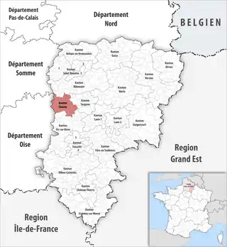
Der Kanton Chauny ist ein französischer Wahlkreis im Département Aisne in der Region Hauts-de-France. Er umfasst 21 Gemeinden im Arrondissement Laon, sein bureau centralisateur ist in Chauny.
| Kanton Chauny | |
|---|---|
| Region | Hauts-de-France |
| Département | Aisne |
| Arrondissement | Laon |
| Bureau centralisateur | Chauny |
| Einwohner | 24.010 (1. Jan. 2019) |
| Bevölkerungsdichte | 143 Einw./km² |
| Fläche | 167,32 km² |
| Gemeinden | 21 |
| INSEE-Code | 0203 |
 Lage des Kantons Chauny im Département Aisne | |

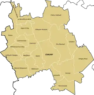
Gemeinden des Kantons
Gemeinden
Der Kanton besteht aus 21 Gemeinden mit insgesamt 24.010 Einwohnern (Stand: 1. Januar 2019) auf einer Gesamtfläche von 167,32 km²:
| Gemeinde | Einwohner 1. Januar 2019 |
Fläche km² |
Dichte Einw./km² |
Code INSEE |
Postleitzahl |
|---|---|---|---|---|---|
| Abbécourt | 502 | 6,05 | 83 | 02001 | 02300 |
| Amigny-Rouy | 729 | 13,16 | 55 | 02014 | 02700 |
| Autreville | 807 | 3,64 | 222 | 02041 | 02300 |
| Beaumont-en-Beine | 179 | 5,45 | 33 | 02056 | 02300 |
| Béthancourt-en-Vaux | 434 | 4,33 | 100 | 02081 | 02300 |
| Caillouël-Crépigny | 442 | 6,70 | 66 | 02139 | 02300 |
| Caumont | 545 | 5,78 | 94 | 02145 | 02300 |
| Chauny | 11.653 | 13,35 | 873 | 02173 | 02300 |
| Commenchon | 216 | 3,37 | 64 | 02207 | 02300 |
| Condren | 708 | 5,63 | 126 | 02212 | 02700 |
| Frières-Faillouël | 983 | 15,34 | 64 | 02336 | 02700 |
| Guivry | 238 | 7,24 | 33 | 02362 | 02300 |
| La Neuville-en-Beine | 193 | 3,82 | 51 | 02546 | 02300 |
| Marest-Dampcourt | 383 | 8,36 | 46 | 02461 | 02300 |
| Neuflieux | 82 | 1,93 | 42 | 02542 | 02300 |
| Ognes | 1.104 | 6,19 | 178 | 02566 | 02300 |
| Pierremande | 255 | 7,65 | 33 | 02599 | 02300 |
| Sinceny | 2.028 | 13,16 | 154 | 02719 | 02300 |
| Ugny-le-Gay | 185 | 5,98 | 31 | 02754 | 02300 |
| Villequier-Aumont | 656 | 12,36 | 53 | 02807 | 02300 |
| Viry-Noureuil | 1.688 | 17,83 | 95 | 02820 | 02300 |
| Kanton Chauny | 24.010 | 167,32 | 143 | 0203 | – |
Die Neuordnung beließ den Kanton Chauny fast unverändert, nur die Gemeinde Pierremande wurde hinzugefügt. Der vorherige Zuschnitt mit 20 Gemeinden entsprach einer Fläche von 158,57 km2. Er besaß vor 2015 einen anderen INSEE-Code als heute, nämlich 0209.
Einwohner
| Bevölkerungsentwicklung | |
|---|---|
| Jahr | Einwohner |
| 1962 | 22.082 |
| 1968 | 23.985 |
| 1975 | 24.450 |
| 1982 | 24.594 |
| 1990 | 24.572 |
| 1999 | 24.056 |
| 2006 | 24.641 |
| 2011 | 24.188 |
Politik
| Vertreter im conseil général des Départements | ||
|---|---|---|
| Amtszeit | Namen | Partei |
| 1998–2015 | Jean-Luc Lanouilh | PCF |
| 2015– | Jean-Luc Lanouilh Fabienne Marchionnia | – |
This article is issued from Wikipedia. The text is licensed under Creative Commons - Attribution - Sharealike. The authors of the article are listed here. Additional terms may apply for the media files, click on images to show image meta data.