Hamel (Nord)
Hamel ist eine französische Gemeinde mit 788 Einwohnern (Stand: 1. Januar 2019) im Département Nord in der Region Hauts-de-France. Sie gehört zum Arrondissement Douai und zum Kanton Aniche (bis 2015: Kanton Arleux).
| Hamel | ||
|---|---|---|
_Nord-France.svg.png.webp)
|
| |
| Staat | Frankreich | |
| Region | Hauts-de-France | |
| Département (Nr.) | Nord (59) | |
| Arrondissement | Douai | |
| Kanton | Aniche | |
| Gemeindeverband | Douaisis | |
| Koordinaten | 50° 17′ N, 3° 4′ O | |
| Höhe | 36–67 m | |
| Fläche | 3,60 km² | |
| Einwohner | 788 (1. Januar 2019) | |
| Bevölkerungsdichte | 219 Einw./km² | |
| Postleitzahl | 59151 | |
| INSEE-Code | 59280 | |
| Website | http://www.hamel59.fr/ | |
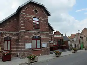 Rathaus (Mairie) von Hamel | ||

Geographie
Hamel liegt etwa neun Kilometer südlich von Douai am Sensée. Umgeben wird Hamel von den Nachbargemeinden Estrées im Norden, Arleux im Süden und Osten, Écourt-Saint-Quentin im Süden und Südwesten, Lécluse im Westen sowie Tortequesne im Westen und Nordwesten.
Bevölkerungsentwicklung
| Jahr | 1962 | 1968 | 1975 | 1982 | 1990 | 1999 | 2006 | 2013 |
| Einwohner | 361 | 410 | 430 | 577 | 669 | 738 | 742 | 785 |
| Quelle: Cassini und INSEE | ||||||||
Sehenswürdigkeiten
Siehe auch: Liste der Monuments historiques in Hamel (Nord)
- Kirche
- Dolmen du Bois
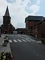 Ortszentrum mit Kirche
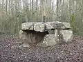 Dolmen du Bois
Literatur
- Le Patrimoine des Communes du Nord. Flohic Editions, Band 1, Paris 2001, ISBN 2-84234-119-8, S. 73–74.
This article is issued from Wikipedia. The text is licensed under Creative Commons - Attribution - Sharealike. The authors of the article are listed here. Additional terms may apply for the media files, click on images to show image meta data.