Distrikt Rímac
Der Distrikt Rímac ist einer der 43 Stadtbezirke der Region Lima Metropolitana in Peru. Er liegt nördlich des Distriktes Lima (Cercado de Lima), mit dem Rímac durch sechs Brücken über den Fluss Rímac verbunden ist. Rímac grenzt auch an die Distrikte Independencia, San Martín de Porres und San Juan de Lurigancho. Viele der erhaltenen Gebäude aus der Kolonialzeit, das „historische Zentrum Limas“, stehen im Distrikt Rímac, das seit 1988 unter dem UNESCO-Welterbe steht.
| Distrikt Rímac | |||
|---|---|---|---|
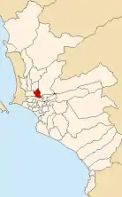 Lage des Distrikts in der Provinz Lima | |||
| Symbole | |||
| |||
| Basisdaten | |||
| Staat | Peru | ||
| Region | regionsfrei | ||
| Provinz | Lima | ||
| Sitz | Rímac | ||
| Fläche | 11,9 km² | ||
| Einwohner | 174.785 (2017) | ||
| Dichte | 14.725 Einwohner pro km² | ||
| Gründung | 2. Februar 1920 | ||
| ISO 3166-2 | PE | ||
| Webauftritt | www.munirimac.gob.pe (spanisch) | ||
| Politik | |||
| Alcalde Distrital | Pedro Guillermo Rosario Tueros (2019–2022) | ||
| Partei | Acción Popular | ||
 | |||


Der Distrikt hat eine Fläche von 11,87 km². Beim Zensus 2017 wurden 174.785 Einwohner gezählt. Im Jahr 1993 lag die Einwohnerzahl bei 189.736, im Jahr 2007 bei 176.169.
Grenzen
- Nördlich: Independencia
- Östlich: San Juan de Lurigancho
- Südlich: Cercado de Lima
- Westlich: San Martín de Porres
Stadtgebiete
Seit 1993 ist Rímac in die folgende Stadtgebiete eingeteilt:
- Caqueta
- Centro Rímac
- Cerro Palomares
- Ciudad y Campo
- El Bosque
- El Manzano
- Huerta Guinea
- La Florida
- La Huerta
- Las Totoritas
- Leoncio Prado
- Perricholi
- Rimac
- Santa Candelaria
- Santa Rosa
- Ventura Rossi
- Villacampa
Weblinks
Commons: Distrikt Rímac – Sammlung von Bildern, Videos und Audiodateien
- Peru: Region Lima (Provinzen und Bezirke) bei www.citypopulation.de
This article is issued from Wikipedia. The text is licensed under Creative Commons - Attribution - Sharealike. The authors of the article are listed here. Additional terms may apply for the media files, click on images to show image meta data.