Distrikt Santa Anita
Der Distrikt Santa Anita ist einer der 43 Stadtbezirke der Region Lima Metropolitana in Peru. Er besitzt eine Fläche von 10,69 km². Beim Zensus 2017 wurden 196.214 Einwohner gezählt. Im Jahr 1993 lag die Einwohnerzahl bei 119.659, im Jahr 2007 bei 184.614. Der Distrikt wurde am 25. Oktober 1989 gegründet. Der Distrikt liegt auf einer Höhe von 240 m.
| Distrikt Santa Anita | |||
|---|---|---|---|
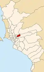
 Lage des Distrikts in der Provinz Lima | |||
| Symbole | |||
| |||
| Basisdaten | |||
| Staat | Peru | ||
| Region | regionsfrei | ||
| Provinz | Lima | ||
| Fläche | 10,7 km² | ||
| Einwohner | 196.214 (2017) | ||
| Dichte | 18.355 Einwohner pro km² | ||
| Gründung | 25. Oktober 1989 | ||
| ISO 3166-2 | PE | ||
| Webauftritt | www.munisantanita.gob.pe (spanisch) | ||
| Politik | |||
| Alcalde Distrital | José Luis Nole Palomino (2019–2022) | ||
| Partei | Partido Popular Cristiano | ||
 | |||

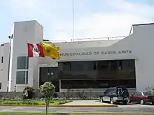
Gebäude der Distriktverwaltung
Geographische Lage
Der Distrikt Santa Anita liegt südlich des Río Rímac 6,5 km östlich vom Stadtzentrum von Lima. Er hat eine Längsausdehnung in WSW-ONO-Richtung von 5,4 km sowie eine Breite von knapp 2,3 km. Der Distrikt grenzt im Westen und Norden an den Distrikt Ate sowie im Osten und Süden an den El Agustino.
Weblinks
Commons: Distrikt Santa Anita – Sammlung von Bildern, Videos und Audiodateien
- Municipalidad Distrital de Santa Anita
- Peru: Region Lima (Provinzen und Bezirke) bei www.citypopulation.de
This article is issued from Wikipedia. The text is licensed under Creative Commons - Attribution - Sharealike. The authors of the article are listed here. Additional terms may apply for the media files, click on images to show image meta data.

