Distrikt Chorrillos
Der Distrikt Chorrillos ist einer der 43 Stadtbezirke der Region Lima Metropolitana in Peru. Er hat eine Fläche von 38,94 km². Beim Zensus 2017 wurden 314.241 Einwohner gezählt. Im Jahr 1993 lag die Einwohnerzahl bei 217.000, im Jahr 2007 bei 286.977. Der Distrikt wurde am 2. Januar 1857 gegründet. Die Distriktverwaltung liegt auf einer Höhe von 37 m. An der Pazifikküste im Südosten des Distrikts befindet sich das Schutzgebiet Refugio de Vida Silvestre Los Pantanos de Villa.
| Distrikt Chorrillos | |||
|---|---|---|---|
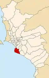
 Lage des Distrikts in der Provinz Lima | |||
| Symbole | |||
| |||
| Basisdaten | |||
| Staat | Peru | ||
| Region | regionsfrei | ||
| Provinz | Lima | ||
| Fläche | 38,9 km² | ||
| Einwohner | 314.241 (2017) | ||
| Dichte | 8070 Einwohner pro km² | ||
| Gründung | 2. Januar 1857 | ||
| ISO 3166-2 | PE | ||
| Webauftritt | www.munichorrillos.gob.pe (spanisch) | ||
| Politik | |||
| Alcalde Distrital | Augusto Sergio Miyashiro Ushikubo (2019–2022) | ||
| Partei | Partido Solidaridad Nacional | ||
.jpg.webp) | |||
Geographische Lage
Der Distrikt Chorrillos liegt an der Pazifikküste 16 km südsüdöstlich vom Stadtzentrum von Lima. Der Distrikt besitzt eine etwa 12,5 km lange Küstenlinie. Er grenzt im Norden an die Distrikte Barranco und Santiago de Surco sowie im Osten an die Distrikte San Juan de Miraflores und Villa El Salvador.
Weblinks
- Municipalidad Distrital de Chorrillos
- Peru: Region Lima (Provinzen und Bezirke) bei www.citypopulation.de

