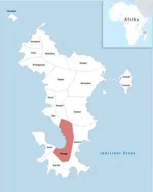
Chirongui
Chirongui ist eine Gemeinde mit 22.626 Einwohnern (Stand 14. Dezember 2017) im französischen Überseegebiet Mayotte.
| Chirongui | |
|---|---|
 | |
| Staat | Frankreich |
| Region | Mayotte |
| Département (Nr.) | Mayotte (976) |
| Kanton | Sada |
| Gemeindeverband | Sud |
| Koordinaten | 12° 56′ S, 45° 9′ O |
| Höhe | 0–652 m |
| Fläche | 25,70 km² |
| Einwohner | 8.920 (14. Dezember 2017) |
| Bevölkerungsdichte | 347 Einw./km² |
| Postleitzahl | 97620 |
| INSEE-Code | 97606 |
Geografie
Chirongui liegt an der Westküste der Hauptinsel Mayottes, an der Bucht von Bouéni. Neben dem Hauptort Chirongui bilden noch die Dörfer Tsimkoura, Mramadoudou, Malamani, Poroani und Miréréni die Gemeinde.[1]
Bevölkerungsentwicklung
| Jahr | 1997 | 2002 | 2007 | 2012 |
| Einwohner | 5.152 | 5.696 | 6.605 | 8.047 |
Einzelnachweise
- Recensement de la population de Mayotte - 2007 bei insee.fr
This article is issued from Wikipedia. The text is licensed under Creative Commons - Attribution - Sharealike. The authors of the article are listed here. Additional terms may apply for the media files, click on images to show image meta data.