Brandonvillers
Brandonvillers ist eine französische Gemeinde im Département Marne in der Region Grand Est. Sie hat eine Fläche von 11,73 km² und 190 Einwohner (2019).
| Brandonvillers | ||
|---|---|---|
|
| |
| Staat | Frankreich | |
| Region | Grand Est | |
| Département (Nr.) | Marne (51) | |
| Arrondissement | Vitry-le-François | |
| Kanton | Sermaize-les-Bains | |
| Gemeindeverband | Perthois-Bocage et Der | |
| Koordinaten | 48° 36′ N, 4° 34′ O | |
| Höhe | 116–175 m | |
| Fläche | 11,73 km² | |
| Einwohner | 190 (1. Januar 2019) | |
| Bevölkerungsdichte | 16 Einw./km² | |
| Postleitzahl | 51290 | |
| INSEE-Code | 51080 | |

Geographie
Die Gemeinde liegt nahe der Quelle des Meldançon, etwa 14 Kilometer südlich der Stadt Vitry-le-François und zehn Kilometer westlich des größten französischen Stausees Lac du Der-Chantecoq. Umgeben wird Brandonvillers von den vier Nachbargemeinden:
| Gigny-Bussy | ||
.svg.png.webp) |
Drosnay | |
| Lignon | Margerie-Hancourt |
Bevölkerungsentwicklung
| Jahr | 1962 | 1968 | 1975 | 1982 | 1990 | 1999 | 2009 | 2018 | |
|---|---|---|---|---|---|---|---|---|---|
| Einwohner | 145 | 131 | 119 | 121 | 149 | 126 | 146 | 187 | |
| Quellen: Cassini und INSEE | |||||||||
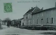
Postkarte von Brandonvillers aus dem Jahr 1907
This article is issued from Wikipedia. The text is licensed under Creative Commons - Attribution - Sharealike. The authors of the article are listed here. Additional terms may apply for the media files, click on images to show image meta data.