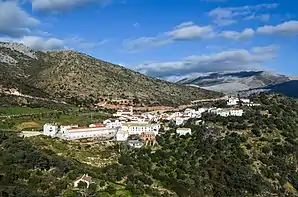
Atajate
Atajate ist eine Gemeinde (municipio) mit 168 Einwohnern (Stand: 1. Januar 2019) in der Provinz Málaga in der Autonomen Region Andalusien im Süden Spaniens.
| Gemeinde Atajate | |||
|---|---|---|---|
 | |||
| Wappen | Karte von Spanien | ||
 |
| ||
| Basisdaten | |||
| Autonome Gemeinschaft: | |||
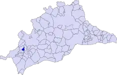
| Provinz: | Málaga | ||
| Comarca: | Serranía de Ronda | ||
| Koordinaten | 36° 38′ N, 5° 15′ W | ||
| Höhe: | 750 msnm | ||
| Fläche: | 10,9 km² | ||
| Einwohner: | 168 (1. Jan. 2019)[1] | ||
| Bevölkerungsdichte: | 15,41 Einw./km² | ||
| Postleitzahl: | 29494 | ||
| Gemeindenummer (INE): | 29021 | ||
| Verwaltung | |||
| Website: | Atajate | ||
| Lage der Gemeinde | |||
 | |||

Geographie
Atajate gehört zur Comarca Serranía de Ronda. Der Ort grenzt an Alpandeire, Benadalid und Jimera de Líbar.
Bevölkerungsentwicklung
| 1842 | 1900 | 1950 | 1981 | 1991 | 2001 | 2011 |
|---|---|---|---|---|---|---|
| 782 | 517 | 284 | 149 | 164 | 173 | 171 |
Weblinks
Einzelnachweise
- Cifras oficiales de población resultantes de la revisión del Padrón municipal a 1 de enero. Bevölkerungsstatistiken des Instituto Nacional de Estadística (Bevölkerungsfortschreibung).
Alameda | Alcaucín | Alfarnate | Alfarnatejo | Algarrobo | Algatocín | Alhaurín de la Torre | Alhaurín el Grande | Almáchar | Almargen | Almogía | Álora | Alozaina | Alpandeire | Antequera | Árchez | Archidona | Ardales | Arenas | Arriate | Atajate | Benadalid | Benahavís | Benalauría | Benalmádena | Benamargosa | Benamocarra | Benaoján | Benarrabá | Campillos | Canillas de Aceituno | Canillas de Albaida | Cañete la Real | Carratraca | Cartajima | Cártama | Casabermeja | Casarabonela | Casares | Coín | Colmenar | Comares | Cómpeta | Cortes de la Frontera | Cuevas Bajas | Cuevas de San Marcos | Cuevas del Becerro | Cútar | El Borge | El Burgo | Estepona | Faraján | Frigiliana | Fuengirola | Fuente de Piedra | Gaucín | Genalguacil | Guaro | Humilladero | Igualeja | Istán | Iznate | Jimera de Líbar | Jubrique | Júzcar | Macharaviaya | Málaga | Manilva | Marbella | Mijas | Moclinejo | Mollina | Monda | Montejaque | Nerja | Ojén | Parauta | Periana | Pizarra | Pujerra | Rincón de la Victoria | Riogordo | Ronda | Salares | Sayalonga | Sedella | Sierra de Yeguas | Teba | Tolox | Torremolinos | Torrox | Totalán | Valle de Abdalajís | Vélez-Málaga | Villanueva de Algaidas | Villanueva de la Concepción | Villanueva de Tapia | Villanueva del Rosario | Villanueva del Trabuco | Viñuela | Yunquera