Amirat
Amirat ist eine französische Gemeinde im Département Alpes-Maritimes in der Region Provence-Alpes-Côte d’Azur. Sie gehör zum Kanton Grasse-1 im Arrondissement Grasse.
| Amirat | ||
|---|---|---|

|
| |
| Staat | Frankreich | |
| Region | Provence-Alpes-Côte d’Azur | |
| Département (Nr.) | Alpes-Maritimes (06) | |
| Arrondissement | Grasse | |
| Kanton | Grasse-1 | |
| Gemeindeverband | Pays de Grasse | |
| Koordinaten | 43° 53′ N, 6° 50′ O | |
| Höhe | 725–1373 m | |
| Fläche | 12,93 km² | |
| Einwohner | 54 (1. Januar 2019) | |
| Bevölkerungsdichte | 4 Einw./km² | |
| Postleitzahl | 06910 | |
| INSEE-Code | 06002 | |
 Amirat | ||

Lage
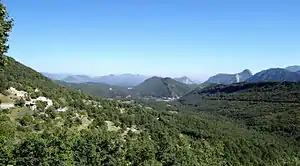
Die Gemeinde liegt im Regionalen Naturpark Préalpes d’Azur. Die angrenzenden Gemeinden sind Val-de-Chalvagne im Westen und im Norden, La Rochette im Nordosten, Collongues im Osten, Les Mujouls im Südosten, Gars im Süden und Briançonnet im Südwesten.
Bevölkerungsentwicklung
| Jahr | 1962 | 1968 | 1975 | 1982 | 1990 | 1999 | 2008 | 2016 |
|---|---|---|---|---|---|---|---|---|
| Einwohner | 29 | 39 | 40 | 72 | 50 | 41 | 44 | 73 |
Literatur
- Le Patrimoine des Communes des Alpes-Maritimes. Flohic Editions, Band 2, Paris 2000, ISBN 2-84234-071-X, S. 790–792.
Weblinks
Commons: Amirat – Sammlung von Bildern, Videos und Audiodateien
This article is issued from Wikipedia. The text is licensed under Creative Commons - Attribution - Sharealike. The authors of the article are listed here. Additional terms may apply for the media files, click on images to show image meta data.