Aiglun (Alpes-Maritimes)
Aiglun ist eine französische Gemeinde im Département Alpes-Maritimes in der Region Provence-Alpes-Côte d’Azur. Sie gehört zum Arrondissement Grasse und zum Kanton Vence.
| Aiglun | ||
|---|---|---|

|
| |
| Staat | Frankreich | |
| Region | Provence-Alpes-Côte d’Azur | |
| Département (Nr.) | Alpes-Maritimes (06) | |
| Arrondissement | Grasse | |
| Kanton | Vence | |
| Gemeindeverband | Alpes d’Azur | |
| Koordinaten | 43° 51′ N, 6° 55′ O | |
| Höhe | 373–1541 m | |
| Fläche | 15,43 km² | |
| Einwohner | 94 (1. Januar 2019) | |
| Bevölkerungsdichte | 6 Einw./km² | |
| Postleitzahl | 06910 | |
| INSEE-Code | 06001 | |
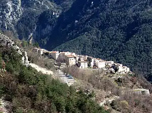 Aiglun | ||

Geografie

Der Estéron
Durch Aiglun, genauer durch die Schlucht namens Clue d’Aiglun, fließt der Estéron. Die angrenzenden Gemeinden sind Sigale im Nordosten, La Roque-en-Provence im Osten, Gréolières im Süden, Le Mas im Westen, Les Mujouls (Berührungspunkt) und Sallagriffon im Nordwesten. Die Gemeinde liegt im Regionalen Naturpark Préalpes d’Azur.
Bevölkerungsentwicklung
| 1962 | 1968 | 1975 | 1982 | 1990 | 1999 | 2006 | 2013 |
|---|---|---|---|---|---|---|---|
| 58 | 50 | 70 | 94 | 91 | 106 | 94 | 89 |
Literatur
- Le Patrimoine des Communes des Alpes-Maritimes. Flohic Editions, Band 2, Paris 2000, ISBN 2-84234-071-X, S. 787–789.
Weblinks
Commons: Aiglun – Sammlung von Bildern, Videos und Audiodateien
This article is issued from Wikipedia. The text is licensed under Creative Commons - Attribution - Sharealike. The authors of the article are listed here. Additional terms may apply for the media files, click on images to show image meta data.