Villers-au-Bois
| Villers-au-Bois | ||
|---|---|---|

|
| |
| Staat | Frankreich | |
| Region | Hauts-de-France | |
| Département (Nr.) | Pas-de-Calais (62) | |
| Arrondissement | Lens | |
| Kanton | Bully-les-Mines | |
| Gemeindeverband | Lens-Liévin | |
| Koordinaten | 50° 22′ N, 2° 40′ O | |
| Höhe | 99–162 m | |
| Fläche | 5,24 km² | |
| Einwohner | 599 (1. Januar 2019) | |
| Bevölkerungsdichte | 114 Einw./km² | |
| Postleitzahl | 62144 | |
| INSEE-Code | 62854 | |

Villers-au-Bois ist eine Gemeinde im französischen Département Pas-de-Calais in der Region Hauts-de-France. Sie gehört dort zum Kanton Bully-les-Mines (bis 2015: Kanton Vimy) im Arrondissement Lens (bis 2015: Arrondissement Arras). Die Einwohner werden Baudets genannt.
Geographie
Villers-au-Bois liegt etwa 15 Kilometer westsüdwestlich von Arras und grenzt an Gouy-Servins im Norden, Carency im Norden und Osten, Mont-Saint-Éloi im Süden und Südosten, Acq im Süden, Camblain-l’Abbé im Westen sowie Servins im Nordwesten.
Bevölkerungsentwicklung
| Jahr | 1962 | 1968 | 1975 | 1982 | 1990 | 1999 | 2008 | 2013 |
|---|---|---|---|---|---|---|---|---|
| Einwohner | 317 | 298 | 311 | 335 | 369 | 379 | 440 | 561 |
Sehenswürdigkeiten
- Kirche aus dem 16. Jahrhundert
- Britischer Soldatenfriedhof
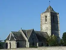
Kirche
Weblinks
Commons: Villers-au-Bois – Sammlung von Bildern, Videos und Audiodateien
This article is issued from Wikipedia. The text is licensed under Creative Commons - Attribution - Sharealike. The authors of the article are listed here. Additional terms may apply for the media files, click on images to show image meta data.