Shelby County (Indiana)
Shelby County[1] ist ein County im Bundesstaat Indiana der Vereinigten Staaten. Der Verwaltungssitz (County Seat) ist Shelbyville.
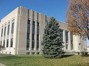 Shelby County Courthouse, gelistet im NRHP | |
| Verwaltung | |
|---|---|
| US-Bundesstaat: | Indiana |
| Verwaltungssitz: | Shelbyville |
| Gründung: | 1821 |
| Demographie | |
| Einwohner: | 44.436 (2010) |
| Bevölkerungsdichte: | 41,57 Einwohner/km2 |
| Geographie | |
| Fläche gesamt: | 1070 km² |
| Wasserfläche: | 1 km² |
| Karte | |
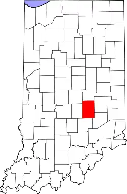 Karte von Shelby County innerhalb von Indiana | |
Geographie
Die Nachbar-Countys (im Norden startend, im Uhrzeigersinn) sind: Hancock County, Rush County, Decatur County, Bartholomew County, Johnson County und Marion County. Shelby County erstreckt sich über eine Fläche von 1070 Quadratkilometern.
Geschichte
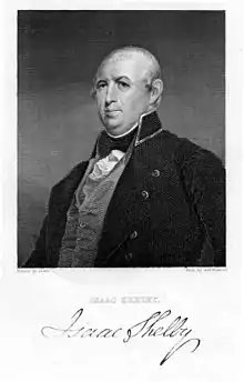
Das Shelby County wurde 1821 aus Teilen des Delaware County gebildet und am 1. April 1822 anerkannt. Benannt wurde es nach General Isaac Shelby, der im Amerikanischen Unabhängigkeitskrieg bei der Schlacht von Kings Mountain die britische Armee geschlagen. Daraufhin wurde er Gouverneur von Kentucky. Im Britisch-Amerikanischen Krieg von 1812 führte er die Truppen aus Kentucky nach Kanada, wo er abermals die britische Armee in der Schlacht am Thames River schlug.
Das County wurde in 14 Townships aufgeteilt: Addison, Brandywine, Hanover, Hendricks, Jackson, Liberty, Marion, Moral, Noble, Shelby, Sugar Creek, Union, Van Buren und Washington.
| Bevölkerungsentwicklung | |||
|---|---|---|---|
| Census | Einwohner | ± in % | |
| 1830 | 6295 | — | |
| 1840 | 12.005 | 90,7 % | |
| 1850 | 15.502 | 29,1 % | |
| 1860 | 19.569 | 26,2 % | |
| 1870 | 21.892 | 11,9 % | |
| 1880 | 25.257 | 15,4 % | |
| 1890 | 25.454 | 0,8 % | |
| 1900 | 26.491 | 4,1 % | |
| 1910 | 26.802 | 1,2 % | |
| 1920 | 25.982 | −3,1 % | |
| 1930 | 26.552 | 2,2 % | |
| 1940 | 25.953 | −2,3 % | |
| 1950 | 28.026 | 8 % | |
| 1960 | 34.093 | 21,6 % | |
| 1970 | 37.797 | 10,9 % | |
| 1980 | 39.887 | 5,5 % | |
| 1990 | 40.307 | 1,1 % | |
| 2000 | 43.445 | 7,8 % | |
| 2010 | 44.436 | 2,3 % | |
| Vor 1900[2] | |||
13 Bauwerke und Stätten des Countys sind im National Register of Historic Places eingetragen (Stand 4. September 2017).[5]
Orte im County
- Beech Brook
- Bengal
- Blue Ridge
- Boggstown
- Brent Woods
- Brookfield
- Candleglo Village
- Clover Village
- Crestmoor
- Edinburgh
- Fairland
- Fenns
- Flat Rock
- Fountaintown
- Freeport
- Geneva
- Green Meadows
- Gwynneville
- Hildebrand Village
- Knighthood Grove
- Knighthood Village
- Lantana Estate
- Lewis Creek
- London
- London Heights
- Marietta
- Marion
- Meiks
- Meltzer
- Middletown
- Morristown
- Mount Auburn
- Norristown
- Pleasant View
- Pleasure Valley
- Prescott
- Rays Crossing
- Riley Village
- Rolling Ridge
- Saint Paul
- Shelbyville
- Sleepy Hollow
- Smithland
- Southeast Manor
- Sugar Creek
- Waldron
- Walkerville
- Wellington Heights
- Addison Township
- Brandywine Township
- Hanover Township
- Hendricks Township
- Jackson Township
- Liberty Township
- Marion Township
- Moral Township
- Noble Township
- Shelby Township
- Sugar Creek Township
- Union Township
- Van Buren Township
- Washington Township
Einzelnachweise
- GNIS-ID: 450387. Abgerufen am 22. Februar 2011 (englisch).
- U.S. Census Bureau - Census of Population and Housing. Abgerufen am 15. März 2011
- Auszug aus Census.gov. Abgerufen am 16. Februar 2011
- Auszug aus census.gov (2000+2010) Abgerufen am 2. April 2012
- Suchmaske Datenbank im National Register Information System. National Park Service, abgerufen am 4. September 2017.
Weblinks
Liste der Countys in Indiana
Adams |
Allen |
Bartholomew |
Benton |
Blackford |
Boone |
Brown |
Carroll |
Cass |
Clark |
Clay |
Clinton |
Crawford |
Daviess |
DeKalb |
Dearborn |
Decatur |
Delaware |
Dubois |
Elkhart |
Fayette |
Floyd |
Fountain |
Franklin |
Fulton |
Gibson |
Grant |
Greene |
Hamilton |
Hancock |
Harrison |
Hendricks |
Henry |
Howard |
Huntington |
Jackson |
Jasper |
Jay |
Jefferson |
Jennings |
Johnson |
Knox |
Kosciusko |
LaGrange |
Lake |
LaPorte |
Lawrence |
Madison |
Marion |
Marshall |
Martin |
Miami |
Monroe |
Montgomery |
Morgan |
Newton |
Noble |
Ohio |
Orange |
Owen |
Parke |
Perry |
Pike |
Porter |
Posey |
Pulaski |
Putnam |
Randolph |
Ripley |
Rush |
St. Joseph |
Scott |
Shelby |
Spencer |
Starke |
Steuben |
Sullivan |
Switzerland |
Tippecanoe |
Tipton |
Union |
Vanderburgh |
Vermillion |
Vigo |
Wabash |
Warren |
Warrick |
Washington |
Wayne |
Wells |
White |
Whitley