Delaware County (Indiana)
Delaware County[1] ist ein County im US-Bundesstaat Indiana der Vereinigten Staaten. Der Sitz der Bezirksregierung ist Muncie.
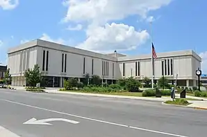 Delaware County Courthouse | |
| Verwaltung | |
|---|---|
| US-Bundesstaat: | Indiana |
| Verwaltungssitz: | Muncie |
| Gründung: | 1827 |
| Demographie | |
| Einwohner: | 117.671 (2010) |
| Bevölkerungsdichte: | 115,59 Einwohner/km2 |
| Geographie | |
| Fläche gesamt: | 1025 km² |
| Wasserfläche: | 7 km² |
| Karte | |
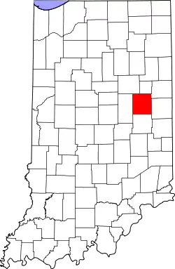 Karte von Delaware County innerhalb von Indiana | |
| Website: www.co.delaware.in.us | |
Geschichte
Delaware County entstand mit Wirkung vom 1. April 1827 und wurde nach den aus den Delaware stammenden Lenni Lenape benannt, die dorthin umgesiedelt worden waren.[2]
43 Bauwerke und Stätten des Countys sind im National Register of Historic Places eingetragen (Stand 31. August 2017).[3]
Bevölkerung
Bei der Volkszählung im Jahr 2000 hatte das County 118.769 Einwohner und eine Bevölkerungsdichte von 117 Einwohnern pro Quadratkilometer.
Geographie
Madison County hat eine Größe von 1025 Quadratkilometern, wovon 1018 Quadratkilometer Land und sieben Quadratkilometer mit Wasser bedeckt sind. Wasser bedeckt somit 0,66 Prozent der Oberfläche des Countys.
Die benachbarten Countys im Uhrzeigersinn von Norden startend sind: Blackford County, Jay County, Randolph County, Henry County, Madison County und Grant County
| Bevölkerungsentwicklung | |||
|---|---|---|---|
| Census | Einwohner | ± in % | |
| 1820 | 3677 | — | |
| 1830 | 2374 | −35,4 % | |
| 1840 | 8843 | 272,5 % | |
| 1850 | 10.843 | 22,6 % | |
| 1860 | 15.753 | 45,3 % | |
| 1870 | 19.030 | 20,8 % | |
| 1880 | 22.926 | 20,5 % | |
| 1890 | 30.131 | 31,4 % | |
| 1900 | 49.624 | 64,7 % | |
| 1910 | 51.414 | 3,6 % | |
| 1920 | 56.377 | 9,7 % | |
| 1930 | 67.270 | 19,3 % | |
| 1940 | 74.963 | 11,4 % | |
| 1950 | 90.252 | 20,4 % | |
| 1960 | 110.938 | 22,9 % | |
| 1970 | 129.219 | 16,5 % | |
| 1980 | 128.587 | −0,5 % | |
| 1990 | 119.659 | −6,9 % | |
| 2000 | 118.769 | −0,7 % | |
| 2010 | 117.671 | −0,9 % | |
| Vor 1900[4] | |||
Orte im County
- Albany
- Andersonville
- Anthony
- Aultshire
- Bethel
- Cammack
- Chesterfield
- Cowan
- Creston
- Cross Roads
- Daleville
- Desoto
- Drew
- Eaton
- Gaston
- Gates Corner
- Granville
- Hyde Park
- Irvington
- Janney
- Liberty Corners
- Mayfield
- Medford
- Middletown Park
- Morningside
- Mount Pleasant
- Muncie
- New Burlington
- Oakville
- Progress
- Reed Station
- Shideler
- Smithfield
- Stockport
- West Muncie
- Wheeling
- Woodland Park
- Yorktown
- Center Township
- Delaware Township
- Hamilton Township
- Harrison Township
- Liberty Township
- Monroe Township
- Mount Pleasant Township
- Niles Township
- Perry Township
- Salem Township
- Union Township
- Washington Township
Einzelnachweise
- GNIS-ID: 450347. Abgerufen am 22. Februar 2011 (englisch).
- Charles Curry Aiken & Joseph Nathan Kane: The American Counties: Origins of County Names, Dates of Creation, Area, and Population Data, 1950–2010. 6. Auflage. Scarecrow Press, Lanham 2013, ISBN 978-0-8108-8762-6, S. 82.
- Suchmaske Datenbank im National Register Information System. National Park Service, abgerufen am 1. September 2017.
- U.S. Census Bureau - Census of Population and Housing. Abgerufen am 15. März 2011
- Auszug aus Census.gov. Abgerufen am 15. Februar 2011
- Auszug aus census.gov (2000+2010) (Memento des Originals vom 9. Juli 2011 auf WebCite) Info: Der Archivlink wurde automatisch eingesetzt und noch nicht geprüft. Bitte prüfe Original- und Archivlink gemäß Anleitung und entferne dann diesen Hinweis. Abgerufen am 2. April 2012
Weblinks
Liste der Countys in Indiana
Adams |
Allen |
Bartholomew |
Benton |
Blackford |
Boone |
Brown |
Carroll |
Cass |
Clark |
Clay |
Clinton |
Crawford |
Daviess |
DeKalb |
Dearborn |
Decatur |
Delaware |
Dubois |
Elkhart |
Fayette |
Floyd |
Fountain |
Franklin |
Fulton |
Gibson |
Grant |
Greene |
Hamilton |
Hancock |
Harrison |
Hendricks |
Henry |
Howard |
Huntington |
Jackson |
Jasper |
Jay |
Jefferson |
Jennings |
Johnson |
Knox |
Kosciusko |
LaGrange |
Lake |
LaPorte |
Lawrence |
Madison |
Marion |
Marshall |
Martin |
Miami |
Monroe |
Montgomery |
Morgan |
Newton |
Noble |
Ohio |
Orange |
Owen |
Parke |
Perry |
Pike |
Porter |
Posey |
Pulaski |
Putnam |
Randolph |
Ripley |
Rush |
St. Joseph |
Scott |
Shelby |
Spencer |
Starke |
Steuben |
Sullivan |
Switzerland |
Tippecanoe |
Tipton |
Union |
Vanderburgh |
Vermillion |
Vigo |
Wabash |
Warren |
Warrick |
Washington |
Wayne |
Wells |
White |
Whitley