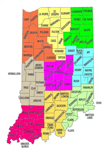
Liste der Countys in Indiana
 Der US-Bundesstaat Indiana ist in 92 Countys unterteilt (Einwohnerzahlen Stand: 2010)[1]
- Adams County (34.387 E.)
- Allen County (355.329 E.)
- Bartholomew County (76.794 E.)
- Benton County (8.854 E.)
- Blackford County (12.766 E.)
- Boone County (56.640 E.)
- Brown County (15.242 E.)
- Carroll County (20.155 E.)
- Cass County (38.966 E.)
- Clark County (110.232 E.)
- Clay County (26.890 E.)
- Clinton County (33.224 E.)
- Crawford County (10.713 E.)
- Daviess County (31.648 E.)
- Dearborn County (50.047 E.)
- Decatur County (25.740 E.)
- DeKalb County (42.223 E.)
- Delaware County (117.671 E.)
- Dubois County (41.889 E.)
- Elkhart County (197.559 E.)
- Fayette County (24.277 E.)
- Floyd County (74.578 E.)
- Fountain County (17.240 E.)
- Franklin County (23.087 E.)
- Fulton County (20.836 E.)
- Gibson County (33.503 E.)
- Grant County (70.061 E.)
- Greene County (33.165 E.)
- Hamilton County (274.569 E.)
- Hancock County (70.002 E.)
- Harrison County (39.364 E.)
- Hendricks County (145.448 E.)
- Henry County (49.462 E.)
- Howard County (82.752 E.)
- Huntington County (37.124 E.)
- Jackson County (42.376 E.)
- Jasper County (33.478 E.)
- Jay County (21.253 E.)
- Jefferson County (32.428 E.)
- Jennings County (28.525 E.)
- Johnson County (139.654 E.)
- Knox County (38.440 E.)
- Kosciusko County (77.358 E.)
- LaGrange County (37.128 E.)
- Lake County (496.005 E.)
- LaPorte County (111.467 E.)
- Lawrence County (46.134 E.)
- Madison County (131.636 E.)
- Marion County (903.393 E.)
- Marshall County (47.051 E.)
- Martin County (10.334 E.)
- Miami County (36.903 E.)
- Monroe County (137.974 E.)
- Montgomery County (38.124 E.)
- Morgan County (68.894 E.)
- Newton County (14.244 E.)
- Noble County (47.536 E.)
- Ohio County (6.128 E.)
- Orange County (19.840 E.)
- Owen County (21.575 E.)
- Parke County (17.339 E.)
- Perry County (19.338 E.)
- Pike County (12.845 E.)
- Porter County (164.343 E.)
- Posey County (25.910 E.)
- Pulaski County (13.402 E.)
- Putnam County (37.963 E.)
- Randolph County (26.171 E.)
- Ripley County (28.818 E.)
- Rush County (17.392 E.)
- Scott County (266.931 E.)
- Shelby County (24.181 E.)
- Spencer County (44.436 E.)
- St. Joseph County (20.952 E.)
- Starke County (23.363 E.)
- Steuben County (34.185 E.)
- Sullivan County (21.475 E.)
- Switzerland County (10.613 E.)
- Tippecanoe County (172.780 E.)
- Tipton County (15.936 E.)
- Union County (7.516 E.)
- Vanderburgh County (179.703 E.)
- Vermillion County (16.212 E.)
- Vigo County (107.848 E.)
- Wabash County (32.888 E.)
- Warren County (8.508 E.)
- Warrick County (59.689 E.)
- Washington County (28.262 E.)
- Wayne County (68.917 E.)
- Wells County (27.636 E.)
- White County (24.643 E.)
- Whitley County (33.292 E.)
- Durch das Missouri Census Data Center ausgewertete Daten der Volkszählung (Seite nicht mehr abrufbar, Suche in Webarchiven) Info: Der Link wurde automatisch als defekt markiert. Bitte prüfe den Link gemäß Anleitung und entferne dann diesen Hinweis. , abgerufen am 4. Oktober 2012
This article is issued from Wikipedia. The text is licensed under Creative Commons - Attribution - Sharealike. The authors of the article are listed here. Additional terms may apply for the media files, click on images to show image meta data.