Bartholomew County
Bartholomew County[3] ist ein County im US-Bundesstaat Indiana. Der County Seat (Verwaltungssitz) ist Columbus.
Bartholomew County Courthouse in Columbus, gelistet im NRHP Nr. 79000031[2] | |
| Verwaltung | |
|---|---|
| US-Bundesstaat: | Indiana |
| Verwaltungssitz: | Columbus |
| Gründung: | 12. Februar 1821 |
| Vorwahl: | 001 812 |
| Demographie | |
| Einwohner: | 76.794 (2010) |
| Bevölkerungsdichte: | 72,93 Einwohner/km2 |
| Geographie | |
| Fläche gesamt: | 1060 km² |
| Wasserfläche: | 7 km² |
| Karte | |
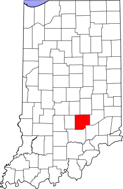 Karte von Bartholomew County innerhalb von Indiana | |
| Website: www.bartholomewco.com | |
Geographie
Bartholomew County hat eine Größe von 1060 Quadratkilometern. Es grenzt im Uhrzeigersinn an folgende Countys: Shelby County, Decatur County, Jennings County, Jackson County, Brown County und Johnson County.
Geschichte
Das Bartholomew County wurde am 12. Februar 1821 gebildet. Benannt wurde es nach Joseph Bartholomew, einem General der Indiana-Miliz, der bei der Besiedlung des Landes eine wichtige Rolle spielte und 1811 in der Schlacht bei Tippecanoe beteiligt war.
Im Bartholomew County liegen sechs National Historic Landmarks.[4] Insgesamt sind 21 Bauwerke und Stätten des Countys im National Register of Historic Places eingetragen (Stand 31. August 2017).[5]
| Bevölkerungswachstum | |||
|---|---|---|---|
| Census | Einwohner | ± in % | |
| 1830 | 5476 | — | |
| 1840 | 10.042 | 83,4 % | |
| 1850 | 12.428 | 23,8 % | |
| 1860 | 17.865 | 43,7 % | |
| 1870 | 21.133 | 18,3 % | |
| 1880 | 22.777 | 7,8 % | |
| 1890 | 23.867 | 4,8 % | |
| 1900 | 24.594 | 3 % | |
| 1910 | 24.813 | 0,9 % | |
| 1920 | 23.887 | −3,7 % | |
| 1930 | 24.864 | 4,1 % | |
| 1940 | 28.276 | 13,7 % | |
| 1950 | 36.108 | 27,7 % | |
| 1960 | 48.198 | 33,5 % | |
| 1970 | 57.022 | 18,3 % | |
| 1980 | 65.088 | 14,1 % | |
| 1990 | 63.657 | −2,2 % | |
| 2000 | 71.435 | 12,2 % | |
| 2010 | 76.794 | 7,5 % | |
| Vor 1900[6] | |||
Einzelnachweise
- Auszug aus dem National Register of Historic Places. Abgerufen am 13. März 2011
- Auszug aus dem National Register of Historic Places. Abgerufen am 13. März 2011
- GNIS-ID: 451683. Abgerufen am 22. Februar 2011 (englisch).
- Listing of National Historic Landmarks by State: Indiana. National Park Service, abgerufen am 31. August 2017.
- Suchmaske Datenbank im National Register Information System. National Park Service, abgerufen am 31. August 2017.
- U.S. Census Bureau - Census of Population and Housing. Abgerufen am 15. März 2011
- Auszug aus Census.gov. Abgerufen am 15. Februar 2011
- Auszug aus census.gov (2000+2010) Abgerufen am 2. April 2012
Weblinks
Liste der Countys in Indiana
Adams |
Allen |
Bartholomew |
Benton |
Blackford |
Boone |
Brown |
Carroll |
Cass |
Clark |
Clay |
Clinton |
Crawford |
Daviess |
DeKalb |
Dearborn |
Decatur |
Delaware |
Dubois |
Elkhart |
Fayette |
Floyd |
Fountain |
Franklin |
Fulton |
Gibson |
Grant |
Greene |
Hamilton |
Hancock |
Harrison |
Hendricks |
Henry |
Howard |
Huntington |
Jackson |
Jasper |
Jay |
Jefferson |
Jennings |
Johnson |
Knox |
Kosciusko |
LaGrange |
Lake |
LaPorte |
Lawrence |
Madison |
Marion |
Marshall |
Martin |
Miami |
Monroe |
Montgomery |
Morgan |
Newton |
Noble |
Ohio |
Orange |
Owen |
Parke |
Perry |
Pike |
Porter |
Posey |
Pulaski |
Putnam |
Randolph |
Ripley |
Rush |
St. Joseph |
Scott |
Shelby |
Spencer |
Starke |
Steuben |
Sullivan |
Switzerland |
Tippecanoe |
Tipton |
Union |
Vanderburgh |
Vermillion |
Vigo |
Wabash |
Warren |
Warrick |
Washington |
Wayne |
Wells |
White |
Whitley