Sainte-Colombe-sur-l’Hers
Sainte-Colombe-sur-l’Hers (okzitanisch Santa Colomba d’Ers) ist eine Gemeinde mit 436 Einwohnern (Stand 1. Januar 2019) in der französischen Verwaltungsregion Okzitanien (vor 2016 Languedoc-Roussillon), im Département Aude, im Arrondissement Limoux und im Kanton La Haute-Vallée de l’Aude (bis 2015 Chalabre). Die Einwohner werden Sainte-Colombiens genannt.
| Sainte-Colombe-sur-l’Hers Santa Colomba d’Ers | ||
|---|---|---|
| ||
| Staat | Frankreich | |
| Region | Okzitanien | |
| Département (Nr.) | Aude (11) | |
| Arrondissement | Limoux | |
| Kanton | La Haute-Vallée de l’Aude | |
| Gemeindeverband | Pyrénées Audoises | |
| Koordinaten | 42° 45′ N, 2° 19′ O | |
| Höhe | 389–764 m | |
| Fläche | 11,03 km² | |
| Einwohner | 436 (1. Januar 2019) | |
| Bevölkerungsdichte | 40 Einw./km² | |
| Postleitzahl | 11230 | |
| INSEE-Code | 11336 | |
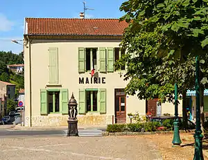 Rathaus (Mairie) von Sainte-Colombe-sur-l’Hers | ||

Geographie
Sainte-Colombe-sur-l’Hers liegt etwa 50 Kilometer südwestlich von Carcassonne am Hers-Vif. Nachbargemeinden sind Montbel im Norden, Rivel im Osten, Lesparrou im Süden sowie Le Peyrat im Westen.
Bevölkerungsentwicklung
| Jahr | 1962 | 1968 | 1975 | 1982 | 1990 | 1999 | 2006 | 2013 |
|---|---|---|---|---|---|---|---|---|
| Einwohner | 711 | 603 | 544 | 534 | 530 | 539 | 511 | 484 |
| Quelle: Cassini und INSEE | ||||||||
Sehenswürdigkeiten
- Kirche La Décollation-de-Saint-Jean-Baptiste
This article is issued from Wikipedia. The text is licensed under Creative Commons - Attribution - Sharealike. The authors of the article are listed here. Additional terms may apply for the media files, click on images to show image meta data.