Saint-Médard-d’Aunis
Saint-Médard-d’Aunis ist eine französische Gemeinde mit 2.302 Einwohnern (Stand: 1. Januar 2019) im Département Charente-Maritime in der Region Nouvelle-Aquitaine. Sie gehört zum Arrondissement La Rochelle, zum Kanton La Jarrie und ist Mitglied im Gemeindeverband La Rochelle Agglomération. Die Einwohner werden Saint-Medardains genannt.
| Saint-Médard-d’Aunis | ||
|---|---|---|
| ||
| Staat | Frankreich | |
| Region | Nouvelle-Aquitaine | |
| Département (Nr.) | Charente-Maritime (17) | |
| Arrondissement | La Rochelle | |
| Kanton | La Jarrie | |
| Gemeindeverband | La Rochelle | |
| Koordinaten | 46° 9′ N, 0° 58′ W | |
| Höhe | 4–44 m | |
| Fläche | 22,57 km² | |
| Einwohner | 2.302 (1. Januar 2019) | |
| Bevölkerungsdichte | 102 Einw./km² | |
| Postleitzahl | 17220 | |
| INSEE-Code | 17373 | |
| Website | saint-medard-daunis.fr | |
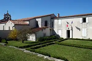 Rathaus (Mairie) von Saint-Médard-d’Aunis | ||

Geografie
Saint-Médard-d’Aunis liegt etwa 13 Kilometer östlich von La Rochelle in der historischen Landschaft Aunis. Umgeben wird Saint-Médard-d’Aunis von den Nachbargemeinden Sainte-Soulle im Norden und Nordwesten, Vérines im Norden, Sainte-Christophe im Süden und Osten, Clavette im Westen und Südwesten sowie Montroy im Westen.
Bevölkerungsentwicklung
| Jahr | 1962 | 1968 | 1975 | 1982 | 1990 | 1999 | 2006 | 2013 |
| Einwohner | 713 | 713 | 764 | 1.002 | 1.073 | 1.253 | 1.449 | 2.038 |
| Quelle: Cassini und INSEE | ||||||||
Sehenswürdigkeiten
- Kirche Saint-Médard aus dem 19. Jahrhundert
- Mühle Cabané aus dem 17. Jahrhundert
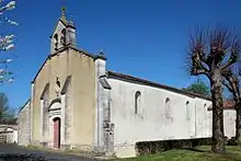
Kirche Saint-Médard
Literatur
- Le Patrimoine des Communes de la Charente-Maritime. Flohic Editions, Band 1, Paris 2002, ISBN 2-84234-129-5, S. 286–287.
This article is issued from Wikipedia. The text is licensed under Creative Commons - Attribution - Sharealike. The authors of the article are listed here. Additional terms may apply for the media files, click on images to show image meta data.