Courçon
Courçon ist eine französische Gemeinde mit 1.776 Einwohnern (Stand: 1. Januar 2019), die im Département Charente-Maritime und in der Region Nouvelle-Aquitaine (vor 2016: Poitou-Charentes) liegt. Sie gehört zum Arrondissement La Rochelle und zum Kanton Marans (bis 2015: Kanton Courçon). Die Einwohner werden Courçonnais genannt.
| Courçon | ||
|---|---|---|
| ||
| Staat | Frankreich | |
| Region | Nouvelle-Aquitaine | |
| Département (Nr.) | Charente-Maritime (17) | |
| Arrondissement | La Rochelle | |
| Kanton | Marans | |
| Gemeindeverband | Aunis Atlantique | |
| Koordinaten | 46° 15′ N, 0° 49′ W | |
| Höhe | 1–43 m | |
| Fläche | 19,21 km² | |
| Einwohner | 1.776 (1. Januar 2019) | |
| Bevölkerungsdichte | 92 Einw./km² | |
| Postleitzahl | 17170 | |
| INSEE-Code | 17127 | |
| Website | https://www.courcon.fr/ | |
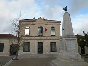 Rathaus (Mairie) von Courçon | ||

Geografie
Courçon liegt etwa 28 Kilometer ostnordöstlich von La Rochelle. Das Gemeindegebiet gehört zum Regionalen Naturpark Marais Poitevin. Umgeben wird Courçon von den Nachbargemeinden Saint-Cyr-du-Doret im Norden und Westen, La Ronde im Norden und Nordosten, La Grève-sur-Mignon im Osten, Benon im Süden sowie Ferrières im Südwesten.
Bevölkerungsentwicklung
| 1962 | 1968 | 1975 | 1982 | 1990 | 1999 | 2006 | 2013 |
|---|---|---|---|---|---|---|---|
| 947 | 946 | 956 | 991 | 990 | 1.097 | 1.456 | 1.730 |
| Quelle: Cassini und INSEE | |||||||
Sehenswürdigkeiten
Siehe auch: Liste der Monuments historiques in Courçon
- Wehrkirche Notre-Dame, Ende des 11. Jahrhunderts erbaut
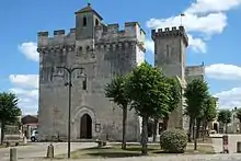
Kirche Notre-Dame
Literatur
- Le Patrimoine des Communes de la Charente-Maritime. Flohic Editions, Band 1, Paris 2002, ISBN 2-84234-129-5, S. 200–201.
This article is issued from Wikipedia. The text is licensed under Creative Commons - Attribution - Sharealike. The authors of the article are listed here. Additional terms may apply for the media files, click on images to show image meta data.