Saint-Denis-de-Méré
Saint-Denis-de-Méré ist eine französische Gemeinde mit 788 Einwohnern (Stand 1. Januar 2019) im Département Calvados in der Region Normandie. Sie gehört zum Arrondissement Vire und zum Kanton Condé-en-Normandie.
| Saint-Denis-de-Méré | ||
|---|---|---|

|
| |
| Staat | Frankreich | |
| Region | Normandie | |
| Département (Nr.) | Calvados (14) | |
| Arrondissement | Vire | |
| Kanton | Condé-en-Normandie | |
| Gemeindeverband | Intercom de la Vire au Noireau | |
| Koordinaten | 48° 52′ N, 0° 31′ W | |
| Höhe | 57–208 m | |
| Fläche | 11,34 km² | |
| Einwohner | 788 (1. Januar 2019) | |
| Bevölkerungsdichte | 69 Einw./km² | |
| Postleitzahl | 14110 | |
| INSEE-Code | 14572 | |
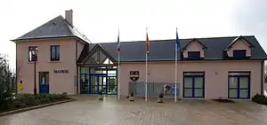 Rathaus (Mairie) | ||

Saint-Denis-de-Méré grenzt an folgende Gemeinden:
| Clécy | Pont-d’Ouilly | |
| Condé-en-Normandie | .svg.png.webp) |
Cahan |
| Saint-Pierre-du-Regard | Berjou |
Bevölkerungsentwicklung
| Jahr | 1962 | 1968 | 1975 | 1982 | 1990 | 1999 | 2006 | 2016 |
| Einwohner | 656 | 759 | 820 | 925 | 835 | 798 | 835 | 837 |
| Quellen: Cassini und INSEE | ||||||||
 Kirche Saint-Denis
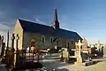 Kapelle Saint-Martin-des-Champs
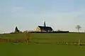 Kapelle aus einer anderen Perspektive
This article is issued from Wikipedia. The text is licensed under Creative Commons - Attribution - Sharealike. The authors of the article are listed here. Additional terms may apply for the media files, click on images to show image meta data.