Ranton
| Ranton | ||
|---|---|---|

|
| |
| Staat | Frankreich | |
| Region | Nouvelle-Aquitaine | |
| Département (Nr.) | Vienne (86) | |
| Arrondissement | Châtellerault | |
| Kanton | Loudun | |
| Gemeindeverband | Pays Loudunais | |
| Koordinaten | 47° 0′ N, 0° 2′ W | |
| Höhe | 45–123 m | |
| Fläche | 6,06 km² | |
| Einwohner | 200 (1. Januar 2019) | |
| Bevölkerungsdichte | 33 Einw./km² | |
| Postleitzahl | 86200 | |
| INSEE-Code | 86205 | |
| Website | http://ranton.monsite.orange.fr/ | |

Ranton ist eine französische Gemeinde mit 200 Einwohnern (Stand: 1. Januar 2019) im Département Vienne in der Region Nouvelle-Aquitaine (vor 2016 Poitou-Charentes); sie gehört zum Arrondissement Châtellerault und zum Kanton Loudun (bis 2015 Les Trois-Moutiers).
Geographie
Ranton liegt etwa 53 Kilometer nordnordwestlich von Poitiers am Canal de la Dive. Nachbargemeinden von Ranton sind Curçay-sur-Dive im Norden und Westen, Glénouze im Osten und Nordosten, Saint-Laon im Südosten sowie Pas-de-Jeu im Süden.
Bevölkerungsentwicklung
| Jahr | 1962 | 1968 | 1975 | 1982 | 1990 | 1999 | 2006 | 2013 |
| Einwohner | 253 | 227 | 219 | 174 | 195 | 202 | 193 | 184 |
| Quelle: Cassini[1] und INSEE | ||||||||
Sehenswürdigkeiten
- Kirche Saint-Martin
- Kirche Saint-Léonard
- Burg bzw. Schloss aus dem 14. Jahrhundert
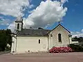 Kirche Saint-Léonard
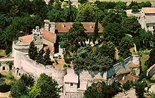 Burg-/Schlossanlage
Literatur
- Le Patrimoine des Communes de la Vienne. Band 2, Flohic Editions, Paris 2002, ISBN 2-84234-128-7.
Weblinks
Commons: Ranton – Sammlung von Bildern, Videos und Audiodateien
This article is issued from Wikipedia. The text is licensed under Creative Commons - Attribution - Sharealike. The authors of the article are listed here. Additional terms may apply for the media files, click on images to show image meta data.