Provinzen von Vanuatu
Der südpazifische Inselstaat Vanuatu ist seit 1994 in sechs Provinzen aufgeteilt.
Deren Namen setzen sich aus den jeweiligen Anfangsbuchstaben der dazugehörigen Inseln zusammen:
Liste
| Lage | Flagge | Provinz | Inseln | Hauptstadt | Fläche in km² | Einwohner |
|---|---|---|---|---|---|---|
.png.webp) |
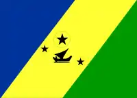 |
Malampa | Malakula, Ambrym, Paama | Lakatoro | 2.779 | 38.161 |
.png.webp) |
Penama | Pentecost, Ambae, Maewo | Sarotamata | 1.198 | 31.852 | |
.png.webp) |
 |
Sanma | Santo, Malo | Luganville | 4.248 | 47.872 |
.png.webp) |
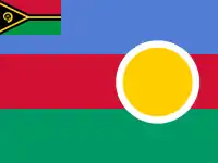 |
Shefa | Shepherd-Inseln, Éfaté | Port Vila | 1.455 | 83.663 |
.png.webp) |
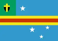 |
Tafea | Tanna, Aniwa, Futuna, Erromango, Aneityum | Isangel | 1.628 | 33.301 |
.png.webp) |
 |
Torba | Torres-Inseln, Banks-Inseln | Sola | 882 | 8.455 |
 |
Vanuatu | Port Vila | 12.190 | 243.304 |
- (Einwohnerzahlen: Volkszählung 2009)
Ältere Verwaltungsgliederung
Von 1985 bis 1994 war Vanuatu in elf Inselregionen aufgeteilt:
- Ambae und Maéwo (Hauptstadt Longana)
- Ambrym (Hauptstadt Eas)
- Banks und Torres (Hauptstadt Sola)
- Éfaté (Hauptstadt Port Vila)
- Épi (Hauptstadt Ringdove)
- Malakula (Hauptstadt Lakatoro)
- Paama (Hauptstadt Liro)
- Pentecost (Hauptstadt Loltong)
- Santo und Malo (Hauptstadt Luganville)
- Shepherd (Hauptstadt Morua)
- Taféa (Hauptstadt Isangel)
This article is issued from Wikipedia. The text is licensed under Creative Commons - Attribution - Sharealike. The authors of the article are listed here. Additional terms may apply for the media files, click on images to show image meta data.