Liste der Provinzen von Papua-Neuguinea
Dies ist eine Liste der Provinzen von Papua-Neuguinea.
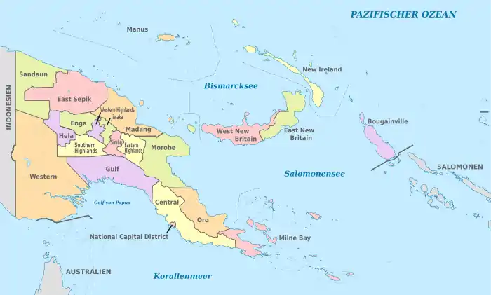
Provinzen von Papua-Neuguinea
| Name der Provinz | Größe in km² | Einwohner (Stand: 2011) | Hauptstadt |
|---|---|---|---|
| Ehemaliges Mandatsgebiet Deutsch-Neuguinea | |||
| Berg-Provinzen (von West nach Ost) | |||
| Enga | 12.800 | 432.045 | Wabag |
| Western Highlands | 4.300 | 362.850 | Mount Hagen |
| Jiwaka | 4.800 | 343.987 | Minj |
| Simbu (Chimbu**) | 6.100 | 376.473 | Kundiawa |
| Eastern Highlands | 11.200 | 579.825 | Goroka |
| Insel-Provinzen (vier Inseln) | |||
| Bougainville* (North Solomons**) | 9.300 | 249.358 | Buka |
| West New Britain | 21.000 | 264.264 | Kimbe |
| East New Britain | 15.500 | 328.369 | Kokopo |
| New Ireland | 9.600 | 194.067 | Kavieng |
| Manus | 2.100 | 60.485 | Lorengau |
| Nordküsten-Provinzen (von West nach Ost) | |||
| Sandaun (West Sepik**) | 36.300 | 248.411 | Vanimo |
| East Sepik | 42.800 | 450.530 | Wewak |
| Madang | 29.000 | 493.906 | Madang |
| Morobe | 34.500 | 674.810 | Lae |
| ehemals deutsche Provinzen | 238.700 | 5.059.380 | |
| Ehemals Australisches Territorium Papua | |||
| Berg-Provinzen | |||
| Hela | 10.500 | 249.449 | Tari |
| Southern Highlands | 15.100 | 510.245 | Mendi |
| Südküsten-Provinzen (von West nach Ost) | |||
| Fly River (Western) | 99.300 | 201.351 | Daru |
| Gulf | 34.500 | 158.197 | Kerema |
| Central Province | 29.500 | 269.756 | Port Moresby |
| Provinzen an der Ostküste und östliche kleine Inseln | |||
| Oro (Northern**) | 22.800 | 186.309 | Popondetta |
| Milne Bay | 14.000 | 276.512 | Alotau |
| National Capital District | 240 | 364.125 | Port Moresby |
| Ehemals britisch-australische Provinzen | 223.900 | 2.215.944 | |
| Gesamt | 462.840 | 7.275.324 | Port Moresby |
- * Bougainville wurde 2005 zur autonomen Provinz erklärt
- ** früherer Name der Provinz
Siehe auch
Weblinks
Commons: Provinzen von Papua-Neuguinea – Sammlung von Bildern, Videos und Audiodateien
- Papua New Guinea: Provinces, Cities & Urban Localities – Population Statistics in Maps and Charts. citypopulation.de, abgerufen am 6. April 2018.
- (Seite nicht mehr abrufbar, Suche in Webarchiven: District and Provincial Profiles) (PDF; 3,0 MB)
Australien | Cookinseln | Fidschi | Kiribati | Marshallinseln | Mikronesien | Nauru | Neuseeland | Palau | Papua-Neuguinea | Salomonen | Samoa | Tonga | Tuvalu | Vanuatu
Amerikanisch-Samoa | Französisch-Polynesien | Guam | Neukaledonien | Niue | Nördliche Marianen | Tokelau | Wallis und Futuna
Verwaltungsgliederung der Staaten von:
Afrika |
Asien |
Australien und Ozeanien |
Europa |
Nord- und Südamerika
This article is issued from Wikipedia. The text is licensed under Creative Commons - Attribution - Sharealike. The authors of the article are listed here. Additional terms may apply for the media files, click on images to show image meta data.