Torba (Vanuatu)
Torba ist die nördlichste Provinz des südpazifischen Inselstaats Vanuatu. Die Provinz umfasst die Torres-Inseln und die Banks-Inseln, letztere einschließlich der kleinen Gruppe der Rowa-Inseln (Reef Islands) und der kleinen, etwas abgelegenen Vétaounde-Insel. Im Süden von Torba schließen sich die Provinzen Sanma und Penama an.
| Torba | |
|---|---|
 | |
| Geographie | |
| Staat: | Vanuatu |
| Gewässer: | Pazifischer Ozean |
| Inseln: | ca. 25 |
| Geographische Lage: | 13° 45′ S, 167° 30′ O |
| Basisdaten | |
| Fläche: | 882 km² |
| Einwohner: | 9359 |
| Bevölkerungsdichte: | 11 Einw./km² |
| Hauptstadt: | Sola |
| Lagekarte | |
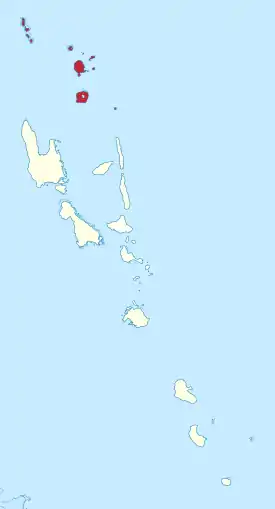 | |
Benennung
Wie bei allen (der insgesamt sechs) Provinzen von Vanuatu leitet sich auch die Bezeichnung Torba von den Namen der in der Region gelegenen Hauptinseln bzw. Inselgruppen, hier von den Torres-Inseln und den Banks-Inseln, ab.
Inseln
![]() Karte mit allen Koordinaten: OSM | WikiMap
Karte mit allen Koordinaten: OSM | WikiMap
Liste der Inseln und Inselgruppen der Provinz Torba:
| Inselname | Aliasname | Koordinaten | Einwohner 2009 | Inselgruppe |
|---|---|---|---|---|
| Vanua Lava | 13° 48′ S, 167° 28′ O | 2.623 | Banks-Inseln | |
| Gaua | Santa Maria Island | 14° 16′ S, 167° 31′ O | 2.491 | Banks-Inseln |
| Mota Lava | 13° 39′ S, 167° 37′ O | 1.451 | Banks-Inseln | |
| Mota | Sugarloaf Island | 13° 51′ S, 167° 42′ O | 683 | Banks-Inseln |
| Mere Lava | Star Peak Island | 14° 27′ S, 168° 04′ O | 647 | Banks-Inseln |
| Uréparapara | Bligh Island | 13° 32′ S, 167° 20′ O | 437 | Banks-Inseln |
| Toga | 13° 25′ S, 166° 42′ O | 276 | Torres-Inseln | |
| Hiw | Hiu | 13° 08′ S, 166° 34′ O | 269 | Torres-Inseln |
| Loh | Lo | 13° 21′ S, 166° 39′ O | 210 | Torres-Inseln |
| Ra | Rah, Aya | 13° 43′ S, 167° 37′ O | 189 | Banks-Inseln |
| Tegua | 13° 15′ S, 166° 37′ O | 58 | Torres-Inseln | |
| Kwakéa | 13° 53′ S, 167° 36′ O | 29 | Banks-Inseln | |
| Metoma | 13° 12′ S, 166° 36′ O | 13 | Torres-Inseln | |
| Mérig | Île Saint Claire | 14° 19′ S, 167° 48′ O | 12 | Banks-Inseln |
| Linua | 13° 20′ S, 166° 38′ O | - | Torres-Inseln | |
| Ngwel | 13° 16′ S, 166° 35′ O | - | Torres-Inseln | |
| Niwula | 13° 53′ S, 167° 37′ O | - | Banks-Inseln | |
| Ravenga | 13° 47′ S, 167° 33′ O | - | Banks-Inseln | |
| Rowa-Inseln | Reef Islands | 13° 37′ S, 167° 13′ O | - | Banks-Inseln |
| Vétaounde | Vet Tagde, Vot Tande | 13° 16′ S, 167° 39′ O | - | Banks-Inseln |
Bevölkerung
Auf einer Landfläche von 882 km² lebten 2009 etwa 9350 Menschen. Die Provinzhauptstadt Sola, auf Vanua Lava gelegen, hatte 2012 rund 1000 Einwohner.[1]