Pirou
Pirou ist eine französische Gemeinde mit 1.432 Einwohnern (Stand: 1. Januar 2019) im Département Manche in der Region Normandie. Die Gemeinde gehört zum Arrondissement Coutances und zum Kanton Créances. Die Einwohner werden Pirouais genannt.
| Pirou | ||
|---|---|---|

|
| |
| Staat | Frankreich | |
| Region | Normandie | |
| Département (Nr.) | Manche (50) | |
| Arrondissement | Coutances | |
| Kanton | Créances | |
| Gemeindeverband | Côte Ouest Centre Manche | |
| Koordinaten | 49° 10′ N, 1° 34′ W | |
| Höhe | 0–40 m | |
| Fläche | 29,32 km² | |
| Einwohner | 1.432 (1. Januar 2019) | |
| Bevölkerungsdichte | 49 Einw./km² | |
| Postleitzahl | 50770 | |
| INSEE-Code | 50403 | |
| Website | http://www.ville-pirou.fr/ | |
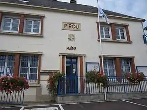 Rathaus (Mairie) von Pirou | ||

Geographie
Pirou liegt etwa 36 Kilometer westnordwestlich von Saint-Lô am Golf von Saint-Malo im Ärmelkanal. Umgeben wird Pirou von den Nachbargemeinden Créances im Norden, La Feuillie im Osten, Muneville-le-Bingard im Südosten sowie Geffosses im Süden.
Bevölkerungsentwicklung
| 1962 | 1968 | 1975 | 1982 | 1990 | 1999 | 2006 | 2018 |
|---|---|---|---|---|---|---|---|
| 1059 | 1005 | 1016 | 1105 | 1224 | 1313 | 1563 | 1432 |
| Quellen: Cassini und INSEE | |||||||
Sehenswürdigkeiten
- Kirche Saint-Martin, Monument historique
- Kapelle von Pirou-Plage
- Burg Pirou, Burganlage aus dem 12. Jahrhundert, seit 1968 Monument historique
- Ruine einer Windmühle aus dem 16. Jahrhundert
- Mühle La Tortue
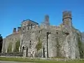 Burg Pirou
 Kirche Saint-Martin
Gemeindepartnerschaft
Mit der rumänischen Gemeinde Săbăoani im Kreis Neamț besteht eine Partnerschaft.
Weblinks
Commons: Pirou – Sammlung von Bildern, Videos und Audiodateien
This article is issued from Wikipedia. The text is licensed under Creative Commons - Attribution - Sharealike. The authors of the article are listed here. Additional terms may apply for the media files, click on images to show image meta data.