Millières (Manche)
Millières ist eine französische Gemeinde mit 776 Einwohnern (Stand: 776) im Département Manche in der Region Normandie. Die Gemeinde gehört zum Arrondissement Coutances und zum Kanton Créances. Die Einwohner werden Milliériens genannt.
| Millières | ||
|---|---|---|
| ||
| Staat | Frankreich | |
| Region | Normandie | |
| Département (Nr.) | Manche (50) | |
| Arrondissement | Coutances | |
| Kanton | Créances | |
| Gemeindeverband | Côte Ouest Centre Manche | |
| Koordinaten | 49° 11′ N, 1° 28′ W | |
| Höhe | 7–53 m | |
| Fläche | 20,55 km² | |
| Einwohner | 776 (1. Januar 2019) | |
| Bevölkerungsdichte | 38 Einw./km² | |
| Postleitzahl | 50190 | |
| INSEE-Code | 50328 | |
 Rathaus (Mairie) von Millières | ||

Geographie
Millières liegt etwa 28 Kilometer westnordwestlich von Saint-Lô. Der Ay begrenzt die Gemeinde im Norden. Umgeben wird Millières von den Nachbargemeinden Vesly im Norden und Nordwesten, Saint-Patrice-de-Claids im Norden und Nordosten, Périers im Osten, Saint-Sauveur-Villages mit Vaudrimesnil im Südosten, Muneville-le-Bingard im Süden, La Feuillie im Westen sowie Lessay im Nordwesten.
Bevölkerungsentwicklung
| 1962 | 1968 | 1975 | 1982 | 1990 | 1999 | 2006 | 2018 |
|---|---|---|---|---|---|---|---|
| 623 | 590 | 591 | 542 | 560 | 562 | 559 | 788 |
| Quellen: Cassini und INSEE | |||||||
Sehenswürdigkeiten
- Kirche Saint-Étienne, Monument historique
- Kapelle Saint-Roch aus dem 15. Jahrhundert
- Kapelle Saint-Wilmer-et-Saint-Wandrille
- Herrenhaus La Champagne aus der Mitte des 17. Jahrhunderts, Monument historique
- Herrenhaus L'Épinerie
- Megalith
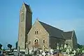 Kirche Saint-Étienne
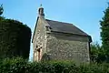 Kapelle Saint-Roch
_03.jpg.webp) Portal des Herrenhauses La Champagne
Portal des Herrenhauses La Champagne
Weblinks
Commons: Millières – Sammlung von Bildern, Videos und Audiodateien
This article is issued from Wikipedia. The text is licensed under Creative Commons - Attribution - Sharealike. The authors of the article are listed here. Additional terms may apply for the media files, click on images to show image meta data.