Piantedo
Piantedo ist eine norditalienische Gemeinde (comune) mit 1407 Einwohnern (Stand 31. Dezember 2019) in der Provinz Sondrio in der Lombardei.
| Piantedo | ||
|---|---|---|
| ? |
| |
| Staat | Italien | |
| Region | Lombardei | |
| Provinz | Sondrio (SO) | |
| Lokale Bezeichnung | Piantee | |
| Koordinaten | 46° 8′ N, 9° 26′ O | |
| Höhe | 215 m s.l.m. | |
| Fläche | 6,7 km² | |
| Einwohner | 1.407 (31. Dez. 2019)[1] | |
| Postleitzahl | 23010 | |
| Vorwahl | 0342 | |
| ISTAT-Nummer | 014048 | |
| Volksbezeichnung | Piantedesi | |
| Schutzpatron | Mariä Geburt (8. September) | |
| Website | Piantedo | |

.svg.png.webp)
Geographie
Die Gemeinde liegt etwa 33 Kilometer westlich von Sondrio und grenzt unmittelbar an die Provinz Lecco. Die umfasst die Fraktion Scese. Die Nachbargemeinden sind Colico (LC), Delebio, Dubino, Gera Lario (CO) und Pagnona (LC).
Verkehr
Durch die Gemeinde führt die Strada Statale 38 dello Stelvio von hier nach Bozen.
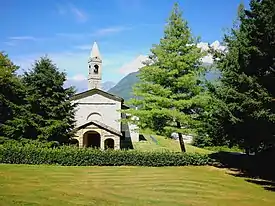
Sehenswürdigkeiten
- Pfarrkirche Santa Maria Nascente
- Oratorium Madonna di Valpozzo.
Literatur
- Piantedo auf tuttitalia.it/lombardia
Weblinks
Einzelnachweise
- Statistiche demografiche ISTAT. Monatliche Bevölkerungsstatistiken des Istituto Nazionale di Statistica, Stand 31. Dezember 2019.

Albaredo per San Marco | Albosaggia | Andalo Valtellino | Aprica | Ardenno | Bema | Berbenno di Valtellina | Bianzone | Bormio | Buglio in Monte | Caiolo | Campodolcino | Caspoggio | Castello dell’Acqua | Castione Andevenno | Cedrasco | Cercino | Chiavenna | Chiesa in Valmalenco | Chiuro | Cino | Civo | Colorina | Cosio Valtellino | Dazio | Delebio | Dubino | Faedo Valtellino | Forcola | Fusine | Gerola Alta | Gordona | Grosio | Grosotto | Lanzada | Livigno | Lovero | Madesimo | Mantello | Mazzo di Valtellina | Mello | Mese | Montagna in Valtellina | Morbegno | Novate Mezzola | Pedesina | Piantedo | Piateda | Piuro | Poggiridenti | Ponte in Valtellina | Postalesio | Prata Camportaccio | Rasura | Rogolo | Samolaco | San Giacomo Filippo | Sernio | Sondalo | Sondrio | Spriana | Talamona | Tartano | Teglio | Tirano | Torre di Santa Maria | Tovo di Sant’Agata | Traona | Tresivio | Val Masino | Valdidentro | Valdisotto | Valfurva | Verceia | Vervio | Villa di Chiavenna | Villa di Tirano