Nottonville
Nottonville ist eine französische Gemeinde mit 289 Einwohnern (Stand: 1. Januar 2019) im Département Eure-et-Loir in der Region Centre-Val de Loire; sie gehört zum Arrondissement Châteaudun und zum Kanton Villages Vovéens. Die Einwohner werden Nottonvillois genannt.
| Nottonville | ||
|---|---|---|
| ||
| Staat | Frankreich | |
| Region | Centre-Val de Loire | |
| Département (Nr.) | Eure-et-Loir (28) | |
| Arrondissement | Châteaudun | |
| Kanton | Villages Vovéens | |
| Gemeindeverband | Cœur de Beauce | |
| Koordinaten | 48° 7′ N, 1° 30′ O | |
| Höhe | 112–143 m | |
| Fläche | 24,71 km² | |
| Einwohner | 289 (1. Januar 2019) | |
| Bevölkerungsdichte | 12 Einw./km² | |
| Postleitzahl | 28140 | |
| INSEE-Code | 28283 | |

Geographie
Nottonville liegt etwa 14 Kilometer nordwestlich von Orléans. Umgeben wird Nottonville von Nachbargemeinden Villiers-Saint-Orien im Norden und Westen, Courbehaye im Nordosten, Cormainville im Osten, Bazoches-en-Dunois im Südosten, Varize im Süden und Südosten, Villemaury im Südwesten sowie Conie-Molitard im Westen.
Bevölkerungsentwicklung
| Jahr | 1962 | 1968 | 1975 | 1982 | 1990 | 1999 | 2006 | 2018 |
| Einwohner | 437 | 400 | 343 | 325 | 275 | 252 | 274 | 295 |
| Quellen: Cassini und INSEE | ||||||||
Sehenswürdigkeiten
- Dolmen Le Palet de Gargantua
- Dolmen und Polissoirs von Le Bois und Vallières
- Kirche Saint-Pierre aus dem 14. Jahrhundert
- früheres Kloster Le Bois aus dem 10. Jahrhundert, seit 1988 Monument historique
- Schloss La Brosse, Monument historique
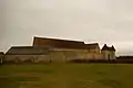 früheres Kloster Le Bois
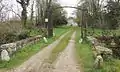 Weg zum Schloss La Brosse
Weblinks
Commons: Nottonville – Sammlung von Bildern, Videos und Audiodateien
This article is issued from Wikipedia. The text is licensed under Creative Commons - Attribution - Sharealike. The authors of the article are listed here. Additional terms may apply for the media files, click on images to show image meta data.