Molompize
Molompize (okzitanisch Molompise) ist eine französische Gemeinde mit 281 Einwohnern (Stand 1. Januar 2019) im Département Cantal in der Region Auvergne-Rhône-Alpes (vor 2016 Auvergne). Sie gehört zum Kanton Saint-Flour-1 (bis 2015 Massiac) und zum Arrondissement Saint-Flour. Die Einwohner werden Molompizois genannt.
| Molompize Molompise | ||
|---|---|---|
.svg.png.webp)
|
| |
| Staat | Frankreich | |
| Region | Auvergne-Rhône-Alpes | |
| Département (Nr.) | Cantal (15) | |
| Arrondissement | Saint-Flour | |
| Kanton | Saint-Flour-1 | |
| Gemeindeverband | Hautes Terres | |
| Koordinaten | 45° 14′ N, 3° 8′ O | |
| Höhe | 549–997 m | |
| Fläche | 17,48 km² | |
| Einwohner | 281 (1. Januar 2019) | |
| Bevölkerungsdichte | 16 Einw./km² | |
| Postleitzahl | 15500 | |
| INSEE-Code | 15127 | |
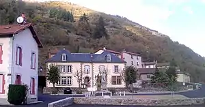 Rathaus (Mairie) von Molompize | ||

Lage
Molompize liegt etwa 58 Kilometer ostnordöstlich von Aurillac. Nachbargemeinden sind Auriac-l’Église im Norden, Massiac im Osten und Nordosten, Bonnac im Süden und Südosten sowie Charmensac im Nordwesten.
Bevölkerungsentwicklung
| Jahr | 1962 | 1968 | 1975 | 1982 | 1990 | 1999 | 2006 | 2011 | 2016 |
|---|---|---|---|---|---|---|---|---|---|
| Einwohner | 520 | 484 | 387 | 407 | 341 | 285 | 292 | 303 | 288 |
| Quellen: Cassini und INSEE | |||||||||
Sehenswürdigkeiten
- Kirche Sainte-Foy, Monument historique seit 2006
- Kapelle Notre-Dame in Vauclair, Monument historique seit 1921
- Kapelle Notre-Dame-de-Bon-Secours
- Burgruine Aurouze, seit 1972 Monument historique
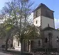 Kirche Sainte-Foy
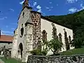 Kapelle Notre-Dame in Vauclair
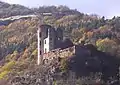 Burgruine Aurouze
Weblinks
Commons: Molompize – Sammlung von Bildern, Videos und Audiodateien
This article is issued from Wikipedia. The text is licensed under Creative Commons - Attribution - Sharealike. The authors of the article are listed here. Additional terms may apply for the media files, click on images to show image meta data.