Laurie
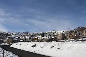
Laurie ist eine französische Gemeinde mit 93 Einwohnern (Stand 1. Januar 2019) im Département Cantal in der Region Auvergne-Rhône-Alpes. Sie gehört zum Arrondissement Saint-Flour und zum Kanton Saint-Flour-1.
| Laurie | ||
|---|---|---|
| ||
| Staat | Frankreich | |
| Region | Auvergne-Rhône-Alpes | |
| Département (Nr.) | Cantal (15) | |
| Arrondissement | Saint-Flour | |
| Kanton | Saint-Flour | |
| Gemeindeverband | Communauté de communes Hautes Terres | |
| Koordinaten | 45° 17′ N, 3° 6′ O | |
| Höhe | 649–1200 m | |
| Fläche | 19,40 km² | |
| Einwohner | 93 (1. Januar 2019) | |
| Bevölkerungsdichte | 5 Einw./km² | |
| Postleitzahl | 15500 | |
| INSEE-Code | 15098 | |
 Laurie | ||

Nachbargemeinden sind Anzat-le-Luguet im Nordwesten, Leyvaux im Norden, Saint-Étienne-sur-Blesle im Nordosten, Auriac-l’Église im Südosten und Molèdes im Südwesten.
Bevölkerungsentwicklung
| Jahr | 1962 | 1968 | 1975 | 1982 | 1990 | 1999 | 2008 | 2015 | |
|---|---|---|---|---|---|---|---|---|---|
| Einwohner | 219 | 200 | 165 | 160 | 139 | 117 | 90 | 95 | |
| Quellen: Cassini und INSEE | |||||||||
Sehenswürdigkeiten
- Kirche Notre-Dame, seit 1927 ein Monument historique
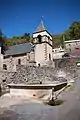 Kirche Notre-Dame und ehemaliges Lavoir
 Ehemaliges Pfarrhaus
Weblinks
Commons: Laurie (Cantal) – Sammlung von Bildern, Videos und Audiodateien
This article is issued from Wikipedia. The text is licensed under Creative Commons - Attribution - Sharealike. The authors of the article are listed here. Additional terms may apply for the media files, click on images to show image meta data.