Livré-la-Touche
Livré-la-Touche (bis 2008 nur Livré) ist eine französische Gemeinde mit 736 Einwohnern (Stand: 1. Januar 2019) im Département Mayenne in der Region Pays de la Loire; sie gehört zum Arrondissement Château-Gontier und zum Kanton Cossé-le-Vivien. Die Einwohner werden Livréens genannt.
| Livré-la-Touche | ||
|---|---|---|
| ||
| Staat | Frankreich | |
| Region | Pays de la Loire | |
| Département (Nr.) | Mayenne (53) | |
| Arrondissement | Château-Gontier | |
| Kanton | Cossé-le-Vivien | |
| Gemeindeverband | Pays de Craon | |
| Koordinaten | 47° 53′ N, 0° 59′ W | |
| Höhe | 39–90 m | |
| Fläche | 30,04 km² | |
| Einwohner | 736 (1. Januar 2019) | |
| Bevölkerungsdichte | 25 Einw./km² | |
| Postleitzahl | 53400 | |
| INSEE-Code | 53135 | |
| Website | http://www.mairie.livre.la.touche.mairie53.fr/ | |

Geographie
Livré-la-Touche liegt etwa 30 Kilometer südwestlich von Laval am Oudon. Umgeben wird Livré-la-Touche von den Nachbargemeinden Méral im Norden und Nordwesten, Cossé-le-Vivien im Norden und Nordosten, Athée im Osten, Craon im Südosten, Niafles im Süden, La Selle-Craonnaise im Südwesten sowie Ballots im Westen.
Bevölkerungsentwicklung
| Jahr | 1962 | 1968 | 1975 | 1982 | 1990 | 1999 | 2006 | 2019 |
|---|---|---|---|---|---|---|---|---|
| Einwohner | 892 | 789 | 798 | 768 | 840 | 787 | 790 | 736 |
| Quellen: Cassini und INSEE | ||||||||
Sehenswürdigkeiten
- Kirche Notre-Dame-de-l’Assomption aus dem 15./16. Jahrhundert, Monument historique
- Kapelle Saint-Denis in Le Blouchet aus dem 20. Jahrhundert
- Herrenhaus von L’Épronnière
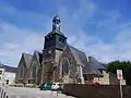 Kirche Notre-Dame-de-l’Assomption
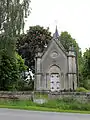 Kapelle Saint-Denis
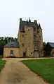 Herrenhaus von L’Épronnière
Literatur
- Le Patrimoine des Communes de la Mayenne. Flohic Editions, Band 1, Paris 2002, ISBN 2-84234-135-X, S. 314–317.
This article is issued from Wikipedia. The text is licensed under Creative Commons - Attribution - Sharealike. The authors of the article are listed here. Additional terms may apply for the media files, click on images to show image meta data.