Châtelain (Mayenne)
Châtelain ist eine französische Gemeinde mit 455 Einwohnern (Stand: 1. Januar 2019) im Département Mayenne in der Region Pays de la Loire; sie gehört zum Arrondissement Château-Gontier und zum Kanton Château-Gontier-sur-Mayenne-1. Die Einwohner der Gemeinde werden Castelinois genannt.
| Châtelain | ||
|---|---|---|
|
| |
| Staat | Frankreich | |
| Region | Pays de la Loire | |
| Département (Nr.) | Mayenne (53) | |
| Arrondissement | Château-Gontier | |
| Kanton | Château-Gontier-sur-Mayenne-1 | |
| Gemeindeverband | Pays de Château-Gontier | |
| Koordinaten | 47° 49′ N, 0° 36′ W | |
| Höhe | 24–91 m | |
| Fläche | 13,99 km² | |
| Einwohner | 455 (1. Januar 2019) | |
| Bevölkerungsdichte | 33 Einw./km² | |
| Postleitzahl | 53200 | |
| INSEE-Code | 53063 | |

Geographie
Châtelain liegt etwa 37 Kilometer nordnordwestlich von Angers. Umgeben wird Châtelain von den Nachbargemeinden Gennes-Longuefuye im Norden, Bierné-les-Villages im Osten und Süden, Coudray im Südwesten sowie Château-Gontier-sur-Mayenne im Westen und Nordwesten.
Bevölkerungsentwicklung
| Jahr | 1793 | 1800 | 1876 | 1901 | 1962 | 1968 | 1975 | 1982 | 1990 | 1999 | 2006 | 2019 |
|---|---|---|---|---|---|---|---|---|---|---|---|---|
| Einwohner | 641 | 541 | 537 | 513 | 394 | 401 | 328 | 341 | 393 | 404 | 467 | 455 |
| Quellen: Cassini und INSEE | ||||||||||||
Sehenswürdigkeiten
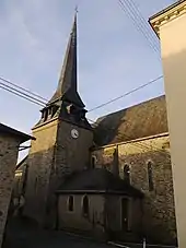
Kirche Saint-Maurice
- Kirche Saint-Maurice
Literatur
- Le Patrimoine des Communes de la Mayenne. Flohic Editions, Band 1, Paris 2002, ISBN 2-84234-135-X, S. 129–130.
This article is issued from Wikipedia. The text is licensed under Creative Commons - Attribution - Sharealike. The authors of the article are listed here. Additional terms may apply for the media files, click on images to show image meta data.