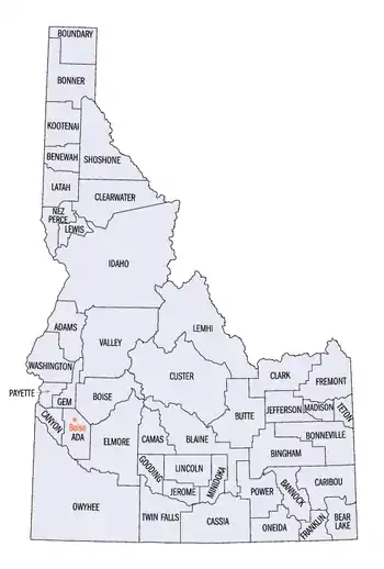
Liste der Countys in Idaho
Der US-Bundesstaat Idaho hat 44 Countys (Einwohnerzahlen Stand: 2010)[1]
- Ada County (392.365 E.)
- Adams County (3.976 E.)
- Bannock County (82.839 E.)
- Bear Lake County (5.986 E.)
- Benewah County (9.285 E.)
- Bingham County (45.607 E.)
- Blaine County (21.376 E.)
- Boise County (7.028 E.)
- Bonner County (40.877 E.)
- Bonneville County (104.234 E.)
- Boundary County (10.972 E.)
- Butte County (2.891 E.)
- Camas County (1.117 E.)
- Canyon County (188.923 E.)
- Caribou County (6.963 E.)
- Cassia County (22.952 E.)
- Clark County (982 E.)
- Clearwater County (8.761 E.)
- Custer County (4.368 E.)
- Elmore County (27.038 E.)
- Franklin County (12.786 E.)
- Fremont County (13.242 E.)
- Gem County (16.719 E.)
- Gooding County (15.464 E.)
- Idaho County (16.267 E.)
- Jefferson County (26.140 E.)
- Jerome County (22.374 E.)
- Kootenai County (138.494 E.)
- Latah County (37.244 E.)
- Lemhi County (7.936 E.)
- Lewis County (3.821 E.)
- Lincoln County (5.208 E.)
- Madison County (37.536 E.)
- Minidoka County (20.069 E.)
- Nez Perce County (39.265 E.)
- Oneida County (4.286 E.)
- Owyhee County (11.526 E.)
- Payette County (22.623 E.)
- Power County (7.817 E.)
- Shoshone County (12.765 E.)
- Teton County (10.170 E.)
- Twin Falls County (77.230 E.)
- Valley County (9.862 E.)
- Washington County (10.198 E.)

Einzelnachweise
- Durch das Missouri Census Data Center ausgewertete Daten der Volkszählung (Seite nicht mehr abrufbar, Suche in Webarchiven) Info: Der Link wurde automatisch als defekt markiert. Bitte prüfe den Link gemäß Anleitung und entferne dann diesen Hinweis. , abgerufen am 4. Oktober 2012
This article is issued from Wikipedia. The text is licensed under Creative Commons - Attribution - Sharealike. The authors of the article are listed here. Additional terms may apply for the media files, click on images to show image meta data.