Lapège
Lapège ist eine französische Gemeinde mit 23 Einwohnern (Stand 1. Januar 2019) im Département Ariège in der Region Okzitanien. Sie gehört zum Kanton Sabarthès und zum Arrondissement Foix.
| Lapège | ||
|---|---|---|
| ||
| Staat | Frankreich | |
| Region | Okzitanien | |
| Département (Nr.) | Ariège (09) | |
| Arrondissement | Foix | |
| Kanton | Sabarthès | |
| Gemeindeverband | Communauté de communes du Pays de Tarascon | |
| Koordinaten | 42° 48′ N, 1° 34′ O | |
| Höhe | 702–1805 m | |
| Fläche | 8,39 km² | |
| Einwohner | 23 (1. Januar 2019) | |
| Bevölkerungsdichte | 3 Einw./km² | |
| Postleitzahl | 09400 | |
| INSEE-Code | 09152 | |
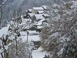 Das Pyrenäendorf Lapège | ||

Sie grenzt im Nordwesten an Gourbit, im Norden an Génat, im Nordosten an Alliat und im Südosten an Capoulet-et-Junac, im Südwesten an Illier-et-Laramade und im Westen an Orus (Berührungspunkt).
Bevölkerungsentwicklung
| Jahr | 1962 | 1968 | 1975 | 1982 | 1990 | 1999 | 2008 | 2016 |
|---|---|---|---|---|---|---|---|---|
| Einwohner | 125 | 84 | 92 | 63 | 46 | 34 | 28 | 29 |
| Quellen: Cassini und INSEE | ||||||||

Dolmen in Lapège
This article is issued from Wikipedia. The text is licensed under Creative Commons - Attribution - Sharealike. The authors of the article are listed here. Additional terms may apply for the media files, click on images to show image meta data.