Labroye
Labroye (niederländisch: De Bomen[1]) ist eine Gemeinde im französischen Département Pas-de-Calais in der Region Hauts-de-France (vor 2016 Nord-Pas-de-Calais). Sie gehört zum Kanton Auxi-le-Château (bis 2015 Hesdin) im Arrondissement Montreuil.
| Labroye | ||
|---|---|---|

|
| |
| Staat | Frankreich | |
| Region | Hauts-de-France | |
| Département (Nr.) | Pas-de-Calais (62) | |
| Arrondissement | Montreuil | |
| Kanton | Auxi-le-Château | |
| Gemeindeverband | Sept Vallées | |
| Koordinaten | 50° 17′ N, 1° 59′ O | |
| Höhe | 12–117 m | |
| Fläche | 8,31 km² | |
| Einwohner | 154 (1. Januar 2019) | |
| Bevölkerungsdichte | 19 Einw./km² | |
| Postleitzahl | 62140 | |
| INSEE-Code | 62481 | |

Geografie, Infrastruktur
Die frühere Route nationale 28 führt über Labroye.
Nachbargemeinden sind Raye-sur-Authie im Nordwesten, Regnauville im Norden, Caumont im Nordosten, Tollent im Südosten und La Boisle im Südwesten.
Bevölkerungsentwicklung
| Jahr | 1962 | 1968 | 1975 | 1982 | 1990 | 1999 | 2008 | 2014 |
|---|---|---|---|---|---|---|---|---|
| Einwohner | 174 | 181 | 144 | 146 | 157 | 173 | 175 | 163 |
Sehenswürdigkeiten
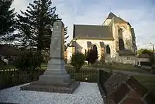
Kirche Saint-Martin und Kriegerdenkmal
- Kirche Saint-Martin
- Kriegerdenkmal
Weblinks
Commons: Labroye – Sammlung von Bildern, Videos und Audiodateien
Einzelnachweis
- De Nederlanden in Frankrijk, Jozef van Overstraeten, 1969
This article is issued from Wikipedia. The text is licensed under Creative Commons - Attribution - Sharealike. The authors of the article are listed here. Additional terms may apply for the media files, click on images to show image meta data.