Wambercourt
| Wambercourt | ||
|---|---|---|
.svg.png.webp)
|
| |
| Staat | Frankreich | |
| Region | Hauts-de-France | |
| Département (Nr.) | Pas-de-Calais (62) | |
| Arrondissement | Montreuil | |
| Kanton | Auxi-le-Château | |
| Gemeindeverband | Sept Vallées | |
| Koordinaten | 50° 26′ N, 2° 1′ O | |
| Höhe | 35–118 m | |
| Fläche | 6,13 km² | |
| Einwohner | 256 (1. Januar 2019) | |
| Bevölkerungsdichte | 42 Einw./km² | |
| Postleitzahl | 62140 | |
| INSEE-Code | 62871 | |

Wambercourt ist eine Gemeinde im französischen Département Pas-de-Calais in der Region Hauts-de-France. Sie gehört zum Kanton Auxi-le-Château im Arrondissement Montreuil.
Nachbargemeinden sind Lebiez im Nordwesten, Fressin im Nordosten, Wamin im Südosten und Cavron-Saint-Martin im Südwesten.
Bevölkerungsentwicklung
| Jahr | 1962 | 1968 | 1975 | 1982 | 1990 | 1999 | 2008 | 2014 |
|---|---|---|---|---|---|---|---|---|
| Einwohner | 179 | 173 | 154 | 172 | 181 | 198 | 228 | 253 |
Sehenswürdigkeiten
- Kirche Saint-Denis
- Backsteinkapelle
- Bruchsteinkapelle
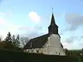 Kirche Saint-Denis
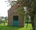 Backsteinkapelle
Weblinks
Commons: Wambercourt – Sammlung von Bildern, Videos und Audiodateien
This article is issued from Wikipedia. The text is licensed under Creative Commons - Attribution - Sharealike. The authors of the article are listed here. Additional terms may apply for the media files, click on images to show image meta data.