Kanton Saint-Ouen-l’Aumône
Der Kanton Saint-Ouen-l’Aumône ist ein französischer Wahlkreis (Kanton) in den Arrondissements Argenteuil und Pontoise im Département Val-d’Oise und in der Region Île-de-France; sein Hauptort ist Saint-Ouen-l’Aumône. Vertreter im Generalrat des Départements ist seit 2004 Andrée Salgues (PS).
| Kanton Saint-Ouen-l’Aumône | |
|---|---|
| Region | Île-de-France |
| Département | Val-d’Oise |
| Arrondissement | Argenteuil Pontoise |
| Hauptort | Saint-Ouen-l’Aumône |
| Einwohner | 57.003 (1. Jan. 2019) |
| Bevölkerungsdichte | 596 Einw./km² |
| Fläche | 95,69 km² |
| Gemeinden | 12 |
| INSEE-Code | 9517 |
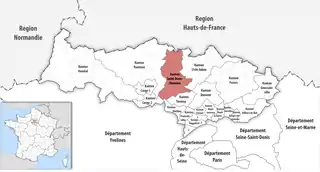 Lage des Kantons Saint-Ouen-l’Aumône im Département Val-d’Oise | |
Gemeinden
Der Kanton besteht aus zwölf Gemeinden mit insgesamt 57.003 Einwohnern (Stand: 1. Januar 2019) auf einer Gesamtfläche von 95,69 km²:
| Gemeinde | Einwohner 1. Januar 2019 |
Fläche km² |
Dichte Einw./km² |
Code INSEE |
Postleitzahl | Arrondissement |
|---|---|---|---|---|---|---|
| Auvers-sur-Oise | 6.813 | 12,80 | 532 | 95039 | 95430 | Pontoise |
| Butry-sur-Oise | 2.276 | 2,78 | 819 | 95120 | 95430 | Pontoise |
| Frépillon | 3.342 | 3,42 | 977 | 95256 | 95740 | Argenteuil |
| Frouville | 349 | 7,45 | 47 | 95258 | 95690 | Pontoise |
| Hédouville | 281 | 5,33 | 53 | 95304 | 95690 | Pontoise |
| Hérouville-en-Vexin | 576 | 8,50 | 68 | 95308 | 95300 | Pontoise |
| Labbeville | 643 | 8,05 | 80 | 95328 | 95690 | Pontoise |
| Mériel | 5.168 | 5,35 | 966 | 95392 | 95630 | Pontoise |
| Méry-sur-Oise | 9.865 | 9,94 | 992 | 95394 | 95540 | Pontoise |
| Nesles-la-Vallée | 1.803 | 13,53 | 133 | 95446 | 95690 | Pontoise |
| Saint-Ouen-l’Aumône | 24.674 | 13,98 | 1.765 | 95572 | 95310 | Pontoise |
| Valmondois | 1.213 | 4,56 | 266 | 95628 | 95760 | Pontoise |
| Kanton Saint-Ouen-l’Aumône | 57.003 | 95,69 | 596 | 9517 | – | – |
Bis zur Neuordnung bestand der Kanton Saint-Ouen-l’Aumône aus den zwei Gemeinden Méry-sur-Oise und Saint-Ouen-l’Aumône. Sein Zuschnitt entsprach einer Fläche von 23,38 km2.
Bevölkerungsentwicklung
| 1968 | 1975 | 1982 | 1990 | 1999 | 2006 | 2011 |
|---|---|---|---|---|---|---|
| 13 426 | 20 656 | 22 839 | 24 852 | 28 595 | 31 859 | 33 021 |
This article is issued from Wikipedia. The text is licensed under Creative Commons - Attribution - Sharealike. The authors of the article are listed here. Additional terms may apply for the media files, click on images to show image meta data.