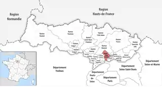
Kanton Montmorency
Der Kanton Montmorency ist ein französischer Wahlkreis (Kanton) im Arrondissement Sarcelles, im Département Val-d’Oise und in der Region Île-de-France; sein Hauptort ist Montmorency. Vertreter im Generalrat des Départements war von 1985 bis 2011 François Longchambon (UMP). Ihm folgte Michèle Berthy (ebenfalls UMP).
| Kanton Montmorency | |
|---|---|
| Region | Île-de-France |
| Département | Val-d’Oise |
| Arrondissement | Sarcelles |
| Hauptort | Montmorency |
| Einwohner | 59.583 (1. Jan. 2019) |
| Bevölkerungsdichte | 3.458 Einw./km² |
| Fläche | 17,23 km² |
| Gemeinden | 6 |
| INSEE-Code | 9515 |
 Lage des Kantons Montmorency im Département Val-d’Oise | |
Gemeinden
Der Kanton besteht aus sechs Gemeinden mit insgesamt 59.583 Einwohnern (Stand: 1. Januar 2019) auf einer Gesamtfläche von 17,23 km²:
| Gemeinde | Einwohner 1. Januar 2019 |
Fläche km² |
Dichte Einw./km² |
Code INSEE |
Postleitzahl |
|---|---|---|---|---|---|
| Andilly | 2.574 | 2,75 | 936 | 95014 | 95580 |
| Enghien-les-Bains | 11.470 | 1,77 | 6.480 | 95210 | 95880 |
| Margency | 2.846 | 0,73 | 3.899 | 95369 | 95580 |
| Montlignon | 2.937 | 2,82 | 1.041 | 95426 | 95680 |
| Montmorency | 21.723 | 5,21 | 4.169 | 95428 | 95160 |
| Soisy-sous-Montmorency | 18.033 | 3,95 | 4.565 | 95598 | 95230 |
| Kanton Montmorency | 59.583 | 17,23 | 3.458 | 9515 | – |
Bis zur Neuordnung bestand der Kanton Montmorency aus den zwei Gemeinden Groslay und Montmorency. Sein Zuschnitt entsprach einer Fläche von 8,31 km2.
Bevölkerungsentwicklung
| 1968 | 1975 | 1982 | 1990 | 1999 | 2006 | 2011 | 2012 |
|---|---|---|---|---|---|---|---|
| 24.133 | 26.056 | 25.712 | 26.830 | 27.923 | 29.427 | 29.565 | 29.518 |
This article is issued from Wikipedia. The text is licensed under Creative Commons - Attribution - Sharealike. The authors of the article are listed here. Additional terms may apply for the media files, click on images to show image meta data.