Kanton Montbard
Der Kanton Montbard ist ein französischer Wahlkreis im Arrondissement Montbard, im Département Côte-d’Or und in der Region Bourgogne-Franche-Comté; sein Hauptort ist Montbard.
| Kanton Montbard | |
|---|---|
| Region | Bourgogne-Franche-Comté |
| Département | Côte-d’Or |
| Arrondissement | Montbard |
| Hauptort | Montbard |
| Einwohner | 17.849 (1. Jan. 2019) |
| Bevölkerungsdichte | 24 Einw./km² |
| Fläche | 747,63 km² |
| Gemeinden | 57 |
| INSEE-Code | 2119 |
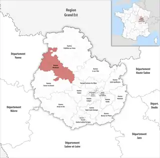 Lage des Kantons Montbard im Département Côte-d’Or | |
Gemeinden
Der Kanton besteht aus 90 Gemeinden mit insgesamt 17.849 Einwohnern (Stand: 1. Januar 2019) auf einer Gesamtfläche von 747,63 km²:
| Gemeinde | Einwohner 1. Januar 2019 |
Fläche km² |
Dichte Einw./km² |
Code INSEE |
Postleitzahl |
|---|---|---|---|---|---|
| Alise-Sainte-Reine | 572 | 3,84 | 149 | 21008 | 21150 |
| Arrans | 67 | 10,46 | 6 | 21025 | 21500 |
| Asnières-en-Montagne | 189 | 28,47 | 7 | 21026 | 21500 |
| Athie | 76 | 5,92 | 13 | 21029 | 21500 |
| Benoisey | 112 | 5,72 | 20 | 21064 | 21500 |
| Boux-sous-Salmaise | 125 | 14,58 | 9 | 21098 | 21690 |
| Buffon | 159 | 8,86 | 18 | 21114 | 21500 |
| Bussy-le-Grand | 315 | 29,71 | 11 | 21122 | 21150 |
| Champ-d’Oiseau | 99 | 4,88 | 20 | 21137 | 21500 |
| Charencey | 37 | 4,72 | 8 | 21144 | 21690 |
| Corpoyer-la-Chapelle | 32 | 4,15 | 8 | 21197 | 21150 |
| Courcelles-lès-Montbard | 86 | 6,15 | 14 | 21204 | 21500 |
| Crépand | 322 | 5,78 | 56 | 21212 | 21500 |
| Darcey | 343 | 18,95 | 18 | 21226 | 21150 |
| Éringes | 61 | 6,00 | 10 | 21248 | 21500 |
| Étais | 79 | 14,12 | 6 | 21252 | 21500 |
| Fain-lès-Montbard | 287 | 7,58 | 38 | 21259 | 21500 |
| Fain-lès-Moutiers | 152 | 9,77 | 16 | 21260 | 21500 |
| Flavigny-sur-Ozerain | 283 | 27,82 | 10 | 21271 | 21150 |
| Fontaines-les-Sèches | 25 | 13,65 | 2 | 21279 | 21330 |
| Fresnes | 159 | 13,30 | 12 | 21287 | 21500 |
| Frôlois | 162 | 34,82 | 5 | 21288 | 21150 |
| Gissey-sous-Flavigny | 88 | 10,25 | 9 | 21299 | 21150 |
| Grésigny-Sainte-Reine | 142 | 7,04 | 20 | 21307 | 21150 |
| Grignon | 203 | 11,71 | 17 | 21308 | 21150 |
| Hauteroche | 79 | 13,33 | 6 | 21314 | 21150 |
| Jailly-les-Moulins | 77 | 9,25 | 8 | 21321 | 21150 |
| La Roche-Vanneau | 141 | 13,21 | 11 | 21528 | 21150 |
| La Villeneuve-les-Convers | 60 | 8,97 | 7 | 21695 | 21450 |
| Lucenay-le-Duc | 183 | 28,95 | 6 | 21358 | 21150 |
| Marigny-le-Cahouët | 323 | 19,25 | 17 | 21386 | 21150 |
| Marmagne | 207 | 12,92 | 16 | 21389 | 21500 |
| Ménétreux-le-Pitois | 420 | 6,63 | 63 | 21404 | 21150 |
| Montbard | 4.848 | 46,28 | 105 | 21425 | 21500 |
| Montigny-Montfort | 296 | 17,17 | 17 | 21429 | 21500 |
| Moutiers-Saint-Jean | 261 | 5,04 | 52 | 21446 | 21500 |
| Mussy-la-Fosse | 87 | 4,38 | 20 | 21448 | 21150 |
| Nesle-et-Massoult | 76 | 23,71 | 3 | 21451 | 21330 |
| Nogent-lès-Montbard | 153 | 6,44 | 24 | 21456 | 21500 |
| Planay | 65 | 8,75 | 7 | 21484 | 21500 |
| Pouillenay | 551 | 15,07 | 37 | 21500 | 21150 |
| Quincerot | 77 | 4,33 | 18 | 21516 | 21500 |
| Quincy-le-Vicomte | 204 | 19,15 | 11 | 21518 | 21500 |
| Rougemont | 149 | 9,57 | 16 | 21530 | 21500 |
| Saint-Germain-lès-Senailly | 131 | 4,98 | 26 | 21550 | 21500 |
| Saint-Rémy | 691 | 13,86 | 50 | 21568 | 21500 |
| Salmaise | 135 | 13,16 | 10 | 21580 | 21690 |
| Seigny | 174 | 8,06 | 22 | 21598 | 21150 |
| Senailly | 140 | 9,47 | 15 | 21604 | 21500 |
| Source-Seine | 63 | 16,35 | 4 | 21084 | 21690 |
| Thenissey | 95 | 10,29 | 9 | 21627 | 21150 |
| Touillon | 457 | 36,84 | 12 | 21641 | 21500 |
| Venarey-les-Laumes | 2.846 | 10,37 | 274 | 21663 | 21150 |
| Verdonnet | 82 | 18,03 | 5 | 21664 | 21330 |
| Verrey-sous-Salmaise | 281 | 8,18 | 34 | 21670 | 21690 |
| Villaines-les-Prévôtes | 144 | 10,57 | 14 | 21686 | 21500 |
| Viserny | 178 | 6,82 | 26 | 21709 | 21500 |
| Kanton Montbard | 17.849 | 747,63 | 24 | 2119 | – |
Bis zur landesweiten Neuordnung der französischen Kantone im März 2015 gehörten zum Kanton Montbard die 28 Gemeinden Arrans, Asnières-en-Montagne, Athie, Benoisey, Buffon, Champ-d’Oiseau, Courcelles-lès-Montbard, Crépand, Éringes, Fain-lès-Montbard, Fain-lès-Moutiers, Fresnes, Lucenay-le-Duc, Marmagne, Montbard, Montigny-Montfort, Moutiers-Saint-Jean, Nogent-lès-Montbard, Quincerot, Quincy-le-Vicomte, Rougemont, Saint-Germain-lès-Senailly, Saint-Rémy, Seigny, Senailly, Touillon, Villaines-les-Prévôtes und Viserny. Sein Zuschnitt entsprach einer Fläche von 352,80 km km2. Er besaß vor 2015 einen anderen INSEE-Code als heute, nämlich 2121.