Kanton L’Huisserie
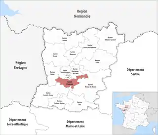
Der Kanton L’Huisserie ist ein französischer Wahlkreis im Arrondissement Laval, im Département Mayenne und in der Region Pays de la Loire; sein Hauptort ist L’Huisserie.
| Kanton L’Huisserie | |
|---|---|
| Region | Pays de la Loire |
| Département | Mayenne |
| Arrondissement | Laval |
| Hauptort | L’Huisserie |
| Einwohner | 15.666 (1. Jan. 2019) |
| Bevölkerungsdichte | 87 Einw./km² |
| Fläche | 179,23 km² |
| Gemeinden | 9 |
| INSEE-Code | 5308 |
 Lage des Kantons L’Huisserie im Département Mayenne | |
Gemeinden
Der Kanton besteht aus neun Gemeinden mit insgesamt 15.666 Einwohnern (Stand: 1. Januar 2019) auf einer Gesamtfläche von 179,23 km²:
| Gemeinde | Einwohner 1. Januar 2019 |
Fläche km² |
Dichte Einw./km² |
Code INSEE |
Postleitzahl |
|---|---|---|---|---|---|
| Ahuillé | 1.831 | 30,56 | 60 | 53001 | 53940 |
| Entrammes | 2.255 | 26,81 | 84 | 53094 | 53260 |
| Forcé | 1.096 | 5,01 | 219 | 53099 | 53260 |
| L’Huisserie | 4.326 | 15,13 | 286 | 53119 | 53970 |
| Louvigné | 1.150 | 12,68 | 91 | 53141 | 53210 |
| Montigné-le-Brillant | 1.322 | 17,80 | 74 | 53157 | 53970 |
| Nuillé-sur-Vicoin | 1.206 | 24,12 | 50 | 53168 | 53970 |
| Parné-sur-Roc | 1.371 | 24,04 | 57 | 53175 | 53260 |
| Soulgé-sur-Ouette | 1.109 | 23,08 | 48 | 53262 | 53210 |
| Kanton L’Huisserie | 15.666 | 179,23 | 87 | 5308 | – |
This article is issued from Wikipedia. The text is licensed under Creative Commons - Attribution - Sharealike. The authors of the article are listed here. Additional terms may apply for the media files, click on images to show image meta data.