Kanton Boutières
Der Kanton Boutières ist ein französischer Wahlkreis im Arrondissement Yssingeaux, im Département Haute-Loire und in der Region Auvergne-Rhône-Alpes.
| Kanton Boutières | |
|---|---|
| Region | Auvergne-Rhône-Alpes |
| Département | Haute-Loire |
| Arrondissement | Yssingeaux |
| Hauptort | Tence |
| Einwohner | 12.532 (1. Jan. 2019) |
| Bevölkerungsdichte | 38 Einw./km² |
| Fläche | 326,44 km² |
| Gemeinden | 12 |
| INSEE-Code | 4303 |
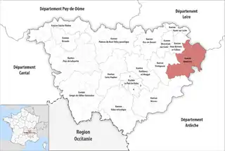 Lage des Kantons Boutières im Département Haute-Loire | |
Gemeinden
Der Kanton besteht aus zwölf Gemeinden mit insgesamt 12.532 Einwohnern (Stand: 2019) auf einer Gesamtfläche von 326,44 km²:
| Gemeinde | Einwohner 1. Januar 2019 |
Fläche km² |
Dichte Einw./km² |
Code INSEE |
Postleitzahl |
|---|---|---|---|---|---|
| Chenereilles | 319 | 14,57 | 22 | 43069 | 43190 |
| Dunières | 2.668 | 34,67 | 77 | 43087 | 43220 |
| Le Mas-de-Tence | 156 | 12,66 | 12 | 43129 | 43190 |
| Montfaucon-en-Velay | 1.149 | 4,95 | 232 | 43141 | 43290 |
| Montregard | 586 | 39,94 | 15 | 43142 | 43290 |
| Raucoules | 940 | 20,84 | 45 | 43159 | 43290 |
| Riotord | 1.179 | 51,90 | 23 | 43163 | 43220 |
| Saint-Bonnet-le-Froid | 213 | 13,06 | 16 | 43172 | 43290 |
| Saint-Jeures | 968 | 34,56 | 28 | 43199 | 43200 |
| Saint-Julien-Molhesabate | 174 | 27,39 | 6 | 43204 | 43220 |
| Saint-Romain-Lachalm | 1.106 | 19,55 | 57 | 43223 | 43620 |
| Tence | 3.074 | 52,35 | 59 | 43244 | 43190 |
| Kanton Boutières | 12.532 | 326,44 | 38 | 4303 | – |
This article is issued from Wikipedia. The text is licensed under Creative Commons - Attribution - Sharealike. The authors of the article are listed here. Additional terms may apply for the media files, click on images to show image meta data.