Géry
| Géry | ||
|---|---|---|
|
| |
| Staat | Frankreich | |
| Region | Grand Est | |
| Département (Nr.) | Meuse (55) | |
| Arrondissement | Bar-le-Duc | |
| Kanton | Bar-le-Duc-1 | |
| Gemeindeverband | Communauté de communes de l’Aire à l’Argonne | |
| Koordinaten | 48° 47′ N, 5° 18′ O | |
| Höhe | 260–376 m | |
| Fläche | 4,80 km² | |
| Einwohner | 53 (1. Januar 2019) | |
| Bevölkerungsdichte | 11 Einw./km² | |
| Postleitzahl | 55000 | |
| INSEE-Code | 55207 | |
 Géry | ||

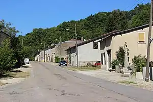
Géry ist eine französische Gemeinde mit 53 Einwohnern (Stand: 1. Januar 2019) im Département Meuse in der Region Grand Est. Sie gehört zum Arrondissement Bar-le-Duc und zum Kanton Bar-le-Duc-1.
Nachbargemeinden sind Érize-Saint-Dizier im Nordwesten, Lavallée im Nordosten und Loisey im Süden.
Bevölkerungsentwicklung
| Jahr | 1962 | 1968 | 1975 | 1982 | 1990 | 1999 | 2008 | 2018 |
|---|---|---|---|---|---|---|---|---|
| Einwohner | 62 | 55 | 40 | 43 | 59 | 65 | 49 | 54 |
_%C3%A9glise_(01).jpg.webp)
Kirche La Chaire-de-Saint-Pierre
Literatur
- Le Patrimoine des Communes de la Meuse. Flohic Editions, Band 2, Paris 1999, ISBN 2-84234-074-4, S. 1076.
Siehe auch
Weblinks
Commons: Géry – Sammlung von Bildern, Videos und Audiodateien
This article is issued from Wikipedia. The text is licensed under Creative Commons - Attribution - Sharealike. The authors of the article are listed here. Additional terms may apply for the media files, click on images to show image meta data.