Eyragues
Eyragues ist eine französische Gemeinde mit 4496 Einwohnern (1. Januar 2019) im Département Bouches-du-Rhône der Region Provence-Alpes-Côte d’Azur. Sie gehört zum Arrondissement Arles und zum Kanton Châteaurenard.
| Eyragues | ||
|---|---|---|
.svg.png.webp)
|
| |
| Staat | Frankreich | |
| Region | Provence-Alpes-Côte d’Azur | |
| Département (Nr.) | Bouches-du-Rhône (13) | |
| Arrondissement | Arles | |
| Kanton | Châteaurenard | |
| Gemeindeverband | Terre de Provence | |
| Koordinaten | 43° 51′ N, 4° 51′ O | |
| Höhe | 11–99 m | |
| Fläche | 20,80 km² | |
| Einwohner | 4.496 (1. Januar 2019) | |
| Bevölkerungsdichte | 216 Einw./km² | |
| Postleitzahl | 13630 | |
| INSEE-Code | 13036 | |
| Website | eyragues.org | |
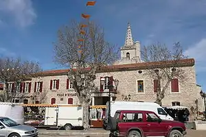 Ortszentrum von Eyragues | ||

Geografie
Die Gemeinde liegt 15 Kilometer südlich von Avignon und sechs Kilometer von Saint-Rémy entfernt. Nachbarorte sind Maillane (4 Kilometer), Graveson (4 Kilometer), Châteaurenard (5 Kilometer), Noves (7 Kilometer) und Verquières (5 Kilometer).[1]
Sehenswürdigkeiten
Verwaltung
Die Gemeinde ist Sitz des Gemeindeverbands Terre de Provence.
Bevölkerungsentwicklung
| Jahr | 1962 | 1968 | 1975 | 1982 | 1990 | 1999 | 2008 | 2017 |
| Einwohner | 2092 | 2288 | 2512 | 2968 | 3504 | 3941 | 4338 | 4468 |
Weblinks
Commons: Eyragues – Sammlung von Bildern, Videos und Audiodateien
Einzelnachweise
This article is issued from Wikipedia. The text is licensed under Creative Commons - Attribution - Sharealike. The authors of the article are listed here. Additional terms may apply for the media files, click on images to show image meta data.