Chepy
Chepy ist eine französische Gemeinde mit 440 Einwohnern (Stand: 1. Januar 2019) im Département Marne in der Region Grand Est (vor 2016 Champagne-Ardenne). Sie gehört zum Arrondissement Châlons-en-Champagne und zum Kanton Châlons-en-Champagne-3.
| Chepy | ||
|---|---|---|
| ||
| Staat | Frankreich | |
| Region | Grand Est | |
| Département (Nr.) | Marne (51) | |
| Arrondissement | Châlons-en-Champagne | |
| Kanton | Châlons-en-Champagne-3 | |
| Gemeindeverband | La Moivre à la Coole | |
| Koordinaten | 48° 54′ N, 4° 26′ O | |
| Höhe | 82–148 m | |
| Fläche | 8,72 km² | |
| Einwohner | 440 (1. Januar 2019) | |
| Bevölkerungsdichte | 50 Einw./km² | |
| Postleitzahl | 51240 | |
| INSEE-Code | 51149 | |
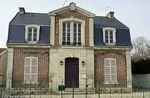 Rathaus (Mairie) von Chepy | ||

Geographie
Chepy liegt etwa sieben Kilometer südsüdöstlich von Châlons-en-Champagne am Fluss Moivre und am Canal latéral à la Marne, die hier in einer Entfernung von etwa einem Kilometer parallel zur Marne verlaufen. Nachbargemeinden von Chepy sind Moncetz-Longevas im Norden und Nordwesten, Courtisols im Nordosten, Marson im Osten und Nordosten, Saint-Germain-la-Ville im Süden und Südosten, Mairy-sur-Marne im Südwesten sowie Sogny-aux-Moulins im Westen.
Durch die Gemeinde führt die Route nationale 44.
Bevölkerungsentwicklung
| Jahr | 1962 | 1968 | 1975 | 1982 | 1990 | 1999 | 2006 | 2011 | 2018 |
|---|---|---|---|---|---|---|---|---|---|
| Einwohner | 243 | 248 | 296 | 348 | 351 | 337 | 374 | 417 | 430 |
| Quellen: Cassini und INSEE | |||||||||
Sehenswürdigkeiten
- Kirche Saint-Jean-Baptiste
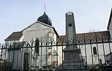
Kriegerdenkmal und Kirche Saint-Jean-Baptiste
This article is issued from Wikipedia. The text is licensed under Creative Commons - Attribution - Sharealike. The authors of the article are listed here. Additional terms may apply for the media files, click on images to show image meta data.