Cagnoncles
Cagnoncles ist eine französische Gemeinde mit 618 Einwohnern (Stand: 1. Januar 2019) im Département Nord in der Region Hauts-de-France. Sie gehört zum Arrondissement Cambrai, zur Communauté d’agglomération de Cambrai und zum Kanton Caudry (bis 2015: Kanton Cambrai-Est).
| Cagnoncles | ||
|---|---|---|
.svg.png.webp)
|
| |
| Staat | Frankreich | |
| Region | Hauts-de-France | |
| Département (Nr.) | Nord (59) | |
| Arrondissement | Cambrai | |
| Kanton | Caudry | |
| Gemeindeverband | Cambrai | |
| Koordinaten | 50° 12′ N, 3° 19′ O | |
| Höhe | 47–86 m | |
| Fläche | 6,19 km² | |
| Einwohner | 618 (1. Januar 2019) | |
| Bevölkerungsdichte | 100 Einw./km² | |
| Postleitzahl | 59161 | |
| INSEE-Code | 59121 | |
| Website | http://www.cagnoncles.fr/ | |
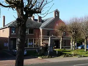 Rathaus (Mairie) von Cagnoncles | ||

Geografie
Cagnoncles liegt etwa sechs Kilometer ostnordöstlich von Cambrai. Nachbargemeinden sind Naves im Norden, Rieux-en-Cambrésis im Osten und Nordosten, Carnières im Osten und Südosten, Cauroir im Süden und Südwesten sowie Escaudœuvres im Westen.
Bevölkerungsentwicklung
| Jahr | 1962 | 1968 | 1975 | 1982 | 1990 | 1999 | 2006 | 2013 |
| Einwohner | 584 | 555 | 526 | 468 | 492 | 465 | 499 | 576 |
| Quelle: Cassini und INSEE | ||||||||
Sehenswürdigkeiten
- Kirche Saint-Géry, ursprünglicher Bau aus dem 11. Jahrhundert im 16. Jahrhundert abgebrannt, wieder aufgebaut im 18. Jahrhundert umgebaut
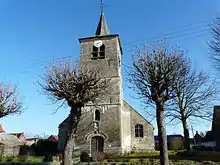
Kirche Saint-Géry
Literatur
- Le Patrimoine des Communes du Nord. Flohic Editions, Band 1, Paris 2001, ISBN 2-84234-119-8, S. 352–353.
Weblinks
Commons: Cagnoncles – Sammlung von Bildern, Videos und Audiodateien
This article is issued from Wikipedia. The text is licensed under Creative Commons - Attribution - Sharealike. The authors of the article are listed here. Additional terms may apply for the media files, click on images to show image meta data.