Bourran
Bourran ist eine französische Gemeinde mit 613 Einwohnern (Stand 1. Januar 2019) im Département Lot-et-Garonne in der Region Nouvelle-Aquitaine (vor 2016 Aquitaine). Die Gemeinde gehört zum Arrondissement Agen und zum Kanton Le Confluent.
| Bourran | ||
|---|---|---|
| ||
| Staat | Frankreich | |
| Region | Nouvelle-Aquitaine | |
| Département (Nr.) | Lot-et-Garonne (47) | |
| Arrondissement | Agen | |
| Kanton | Le Confluent | |
| Gemeindeverband | Confluent et Coteaux de Prayssas | |
| Koordinaten | 44° 21′ N, 0° 24′ O | |
| Höhe | 27–145 m | |
| Fläche | 18,31 km² | |
| Einwohner | 613 (1. Januar 2019) | |
| Bevölkerungsdichte | 33 Einw./km² | |
| Postleitzahl | 47320 | |
| INSEE-Code | 47038 | |
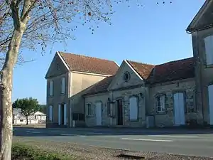 Rathaus (Mairie) von Bourran | ||

Geografie
Bourran liegt etwa 19 Kilometer westnordwestlich von Agen am Lot, der die Gemeinde im Nordwesten begrenzt. Umgeben wird Bourran von den Nachbargemeinden Clairac im Norden und Westen, Lafitte-sur-Lot im Norden und Nordosten, Lacépède im Osten, Saint-Salvy im Südosten, Galapian im Süden, Aiguillon im Westen und Südwesten sowie Nicole im Westen.
Bevölkerungsentwicklung
| 1962 | 1968 | 1975 | 1982 | 1990 | 1999 | 2006 | 2018 | |
|---|---|---|---|---|---|---|---|---|
| 677 | 661 | 605 | 608 | 613 | 578 | 609 | 614 | |
| Quellen: Cassini und INSEE | ||||||||
Sehenswürdigkeiten
- protestantische Kirche
- Kirche Saint-Pierre in Colleignes
- Schloss La Tour de Rance, seit 1993 Monument historique
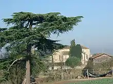
Kirche Saint-Pierre
This article is issued from Wikipedia. The text is licensed under Creative Commons - Attribution - Sharealike. The authors of the article are listed here. Additional terms may apply for the media files, click on images to show image meta data.