Bourg-Saint-Christophe
| Bourg-Saint-Christophe | ||
|---|---|---|
.svg.png.webp)
|
| |
| Staat | Frankreich | |
| Region | Auvergne-Rhône-Alpes | |
| Département (Nr.) | Ain (01) | |
| Arrondissement | Belley | |
| Kanton | Meximieux | |
| Gemeindeverband | Plaine de l’Ain | |
| Koordinaten | 45° 53′ N, 5° 10′ O | |
| Höhe | 207–305 m | |
| Fläche | 8,91 km² | |
| Einwohner | 1.457 (1. Januar 2019) | |
| Bevölkerungsdichte | 164 Einw./km² | |
| Postleitzahl | 01800 | |
| INSEE-Code | 01054 | |
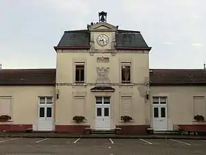 Früheres Rathaus (Mairie) und Schule von Bourg-Saint-Christophe | ||

Bourg-Saint-Christophe ist eine französische Gemeinde mit 1.457 Einwohnern (Stand: 1. Januar 2019) im Département Ain der Region Auvergne-Rhône-Alpes. Die Gemeinde gehört zum Arrondissement Belley und zum Kanton Meximieux. Die Einwohner werden Bourtoirs genannt.
Geografie
Bourg-Saint-Christophe liegt etwa 25 Kilometer ostnordöstlich von Lyon. Umgeben wird Bourg-Saint-Christophe von den Nachbargemeinden Faramans im Norden und Nordwesten, Pérouges im Osten und Nordosten, Béligneux im Süden und Südwesten sowie Bressolles im Westen und Südwesten.
Bevölkerungsentwicklung
| Jahr | 1962 | 1968 | 1975 | 1982 | 1990 | 1999 | 2006 | 2017 |
| Einwohner | 474 | 489 | 515 | 659 | 716 | 824 | 1035 | 1366 |
| Quellen: Cassini und INSEE | ||||||||
Sehenswürdigkeiten
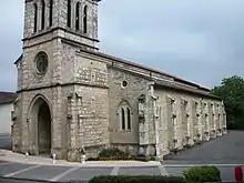
Kirche Saint-Christophe
- Kirche Saint-Christophe
- Ruine der Kapelle Notre-Dame-de-Lorette
- Burgruine
Weblinks
Commons: Bourg-Saint-Christophe – Sammlung von Bildern, Videos und Audiodateien
This article is issued from Wikipedia. The text is licensed under Creative Commons - Attribution - Sharealike. The authors of the article are listed here. Additional terms may apply for the media files, click on images to show image meta data.