Armaillé
Armaillé ist eine französische Gemeinde mit 319 Einwohnern (Stand: 1. Januar 2019) im Kanton Segré-en-Anjou Bleu (bis 2015: Kanton Pouancé) im Arrondissement Segré im Département Maine-et-Loire und in der Region Pays de la Loire. Die Einwohner werden Armailléens genannt.
| Armaillé | ||
|---|---|---|
| ||
| Staat | Frankreich | |
| Region | Pays de la Loire | |
| Département (Nr.) | Maine-et-Loire (49) | |
| Arrondissement | Segré | |
| Kanton | Segré-en-Anjou Bleu | |
| Gemeindeverband | Anjou Bleu Communauté | |
| Koordinaten | 47° 43′ N, 1° 8′ W | |
| Höhe | 39–100 m | |
| Fläche | 16,89 km² | |
| Einwohner | 319 (1. Januar 2019) | |
| Bevölkerungsdichte | 19 Einw./km² | |
| Postleitzahl | 49420 | |
| INSEE-Code | 49010 | |

Geografie
Armaillé liegt etwa 60 Kilometer ostnordöstlich von Angers in der Segréen. Umgeben wird Armaillé fast vollständig von Ombrée d’Anjou sowie Juigné-des-Moutiers im Südwesten.
Bevölkerungsentwicklung
| 1962 | 1968 | 1975 | 1982 | 1990 | 1999 | 2006 | 2018 |
|---|---|---|---|---|---|---|---|
| 453 | 403 | 335 | 307 | 297 | 290 | 298 | 317 |
| Quellen: Cassini und INSEE | |||||||
Sehenswürdigkeiten
- Kirche Saint-Pierre-Saint-Paul, 1875 erbaut
- Priorat von La Primaudière, 1207 begründet
- Schloss Le Bois-Gélin aus dem 16. Jahrhundert
Siehe auch: Liste der Monuments historiques in Armaillé
 Kirche Saint-Pierre-Saint-Paul
.JPG.webp) Priorat von La Primaudière
Priorat von La Primaudière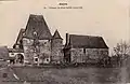 Schloss Le Bois-Gélin
Literatur
- Le Patrimoine des Communes de Maine-et-Loire. Flohic Editions, Band 2, Paris 2001, ISBN 2-84234-117-1, S. 1017–1018.
This article is issued from Wikipedia. The text is licensed under Creative Commons - Attribution - Sharealike. The authors of the article are listed here. Additional terms may apply for the media files, click on images to show image meta data.