Argelouse
Argelouse (okzitanisch: Argelosa) ist eine französische Gemeinde mit 97 Einwohnern (Stand: 1. Januar 2019) im Département Landes in der Region Nouvelle-Aquitaine. Sie gehört administrativ zum Arrondissement Mont-de-Marsan und ist Teil des Kantons Haute Lande Armagnac (bis 2015: Kanton Sore).
| Argelouse Argelosa | ||
|---|---|---|
| ||
| Staat | Frankreich | |
| Region | Nouvelle-Aquitaine | |
| Département (Nr.) | Landes (40) | |
| Arrondissement | Mont-de-Marsan | |
| Kanton | Haute Lande Armagnac | |
| Gemeindeverband | Cœur Haute Lande | |
| Koordinaten | 44° 22′ N, 0° 39′ W | |
| Höhe | 39–73 m | |
| Fläche | 22,86 km² | |
| Einwohner | 97 (1. Januar 2019) | |
| Bevölkerungsdichte | 4 Einw./km² | |
| Postleitzahl | 40430 | |
| INSEE-Code | 40008 | |

Geographie
Argelouse liegt etwa 50 Kilometer nordnordwestlich von Mont-de-Marsan und etwa 60 Kilometer südlich von Bordeaux am Petite Leyre in der Region Armagnac. Umgeben wird Argelouse von den Nachbargemeinden Saint-Symphorien im Norden und Nordosten, Sore im Süden und Osten sowie Belhade im Westen.
Bevölkerungsentwicklung
| Jahr | 1962 | 1968 | 1975 | 1982 | 1990 | 1999 | 2006 | 2017 |
|---|---|---|---|---|---|---|---|---|
| Einwohner | 53 | 37 | 37 | 55 | 54 | 55 | 81 | 93 |
| Quellen: Cassini und INSEE | ||||||||
Sehenswürdigkeiten
- Kirche Saint-André
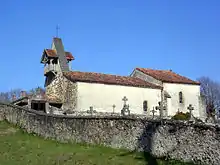
Kirche Saint-André
This article is issued from Wikipedia. The text is licensed under Creative Commons - Attribution - Sharealike. The authors of the article are listed here. Additional terms may apply for the media files, click on images to show image meta data.